Research by Joel Provenzano
Over the past several months (and for years before that), we’ve written a lot about Pasco County’s so-called “Connected City,” a “special land use plan” established the State of Florida in 2015 that already is increasing the size of the Wesley Chapel area by thousands of residences and millions of square feet of commercial uses.
But, not only is the Connected City not alone in Pasco in having a special land use plan, there is another such plan — first established in 2008, and implemented by Pasco in 2009, or six years before the state helped Pasco create the Connected City.
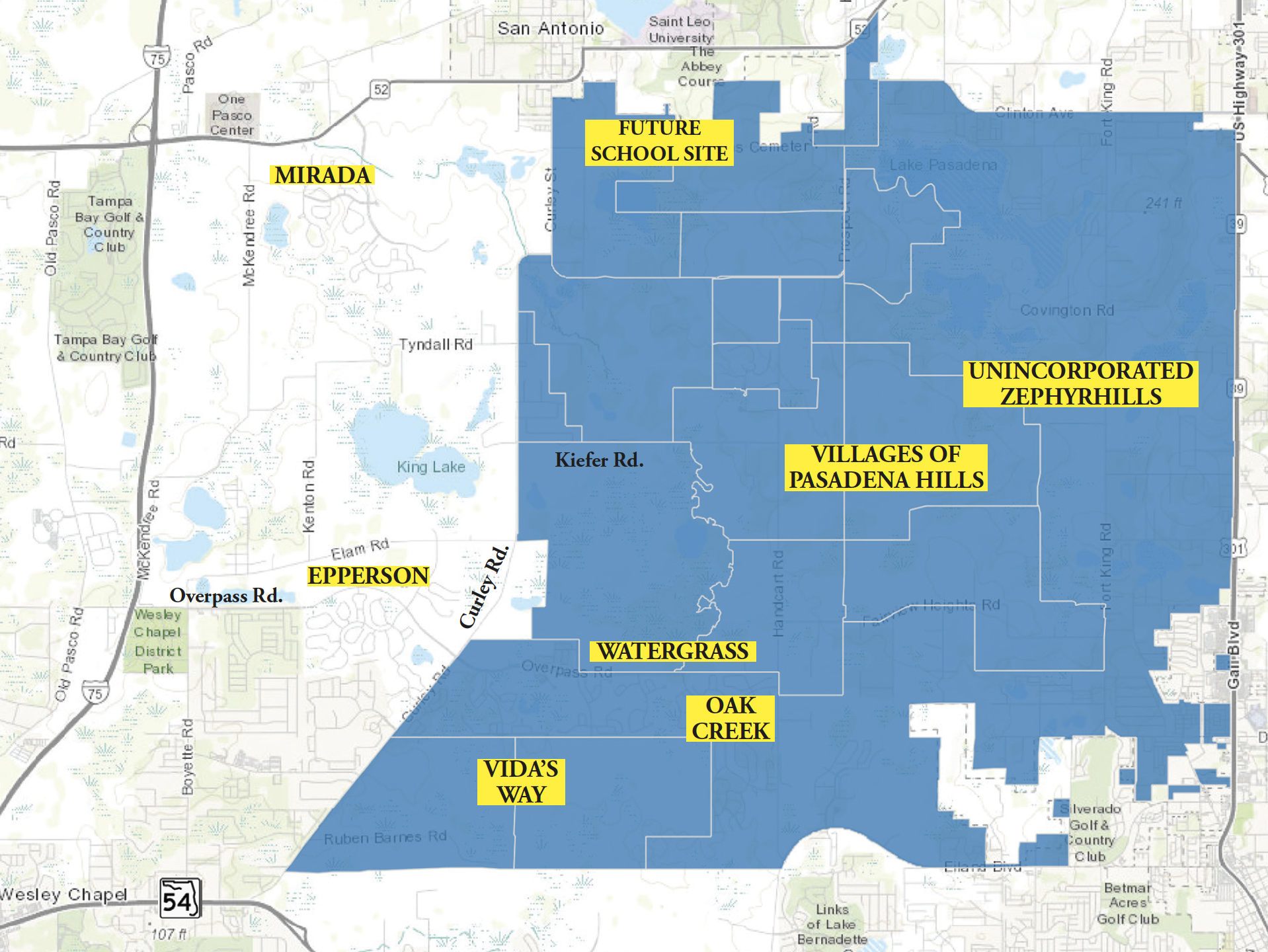
This special land use plan is called The Villages of Pasadena Hills (VOPH), but most Wesley Chapel residents know very little (if anything) about this huge, 20,000+-acre (see top map on this page) land use plan that includes 13 planned villages designated by letters A-M (map below).
“Pasadena Hills” is actually its own “Census Designated Place” — with a 2010 population of more than 7,000 people — some of whom are located in Wesley Chapel.
The Wesley Chapel residents in that number live primarily currently in the 1,162 residences in the Watergrass community north and south of Overpass Rd. and east of Curley Rd., but also in the smaller Oak Creek community, which is just south of Watergrass on the Wesley Chapel (west) wide of Handcart Rd.
But, a lot of those current VOPH residents live east of Handcart Rd. in Zephyrhills, including in the communities of Stonebridge, Hidden Creek and Silverado. The northern boundary of VOPH also touches S.R. 52 and includes a portion of San Antonio and extends to south of the incorporated town of St. Leo.
The only community in VOPH that currently has homes being built is Vida’s Way, which we first told you about several months ago. This Pulte Homes community currently has its 305-home Phase 1 in development, with approximately 300 more in Phase 2, in VOPH Villages L&M (near the bottom of the bottom map, right), but there is a lot more to come.
But, Where?
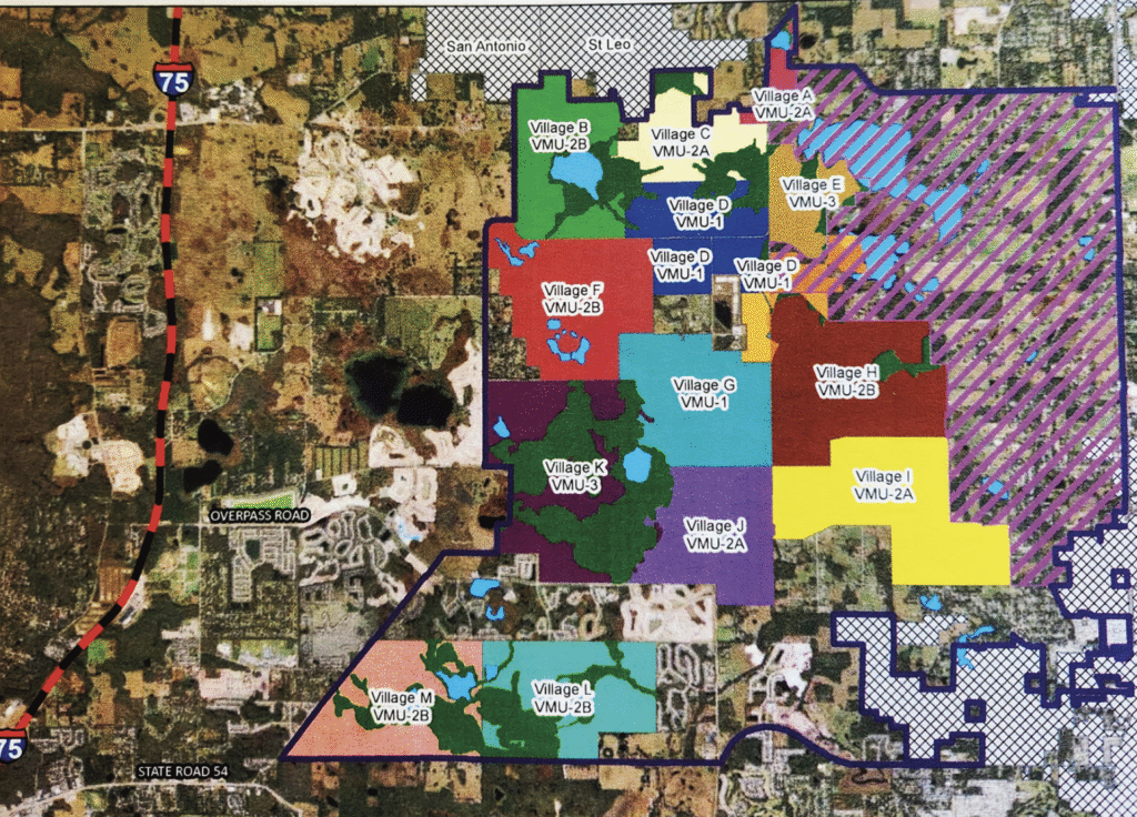
Among the planned communities coming soon to VOPH are two Lennar developments in Village F, one called Twinflowers, with 129 single-family (SF) homes and 60 townhomes, and the other called Acacia Fields, with 204 SF homes. Both of these new subdivisions are located off the existing Tyndall Rd., which is in the VOPH plan to be expanded and connected from Curley Rd. on the west side and east to Handcart Rd.
Also getting ready to build in Village F is Magnolia Island by Homes by WestBay, on the north side of Kiefer Rd., which also is planned to extend from Curley Rd. to Handcart Rd. Magnolia Island is planned to include 269 SF and 120 townhomes.
Two additional communities are getting ready to build in VOPH. One is Chapel Manor by KB Homes, which will be 146 SF homes located east of Handcart Rd. in Village G, which will have Zephyrhills addresses.
Also to be located in unincorporated Zephyrhills will be Pasadena Ridge, by Homes by WestBay, which will build another 579 SF homes in Villages G&H.
In all, that makes 2,112 home sites to be added in VOPH in the near future and all of these new communities — except Phase 1 of Vida’s Way — were just finalized over the summer. Many more communities are being proposed and/or are going through the permitting phase in VOPH, which has entitlements for 41,987 total residential units, 2,260,000 sq. ft. of commercial entitlements and 500,000 sq. ft. of office entitlements. Among those additional developments are:
Harvest Hills South, which is located in Village H, is proposed to include around 300 homes, both SF and townhomes, near Prospect and Handcart Rds.
Depue East MPUD, located in Village L, is planned for 931 acres and could include up to 1,700 single-family homes, 300 townhomes, 300 apartments, and 20,000 sq. ft. of commercial space.
There also is an as-yet-unnamed MPUD proposed for Villages J, K, & G, involving 614 residential units, including 175 townhomes and SF homes, located between Kiefer Rd. and Overpass Rd., west of Handcart Rd.
There also was a rezoning last year in Village B, with plans for 796 dwelling units and 75,000 square feet of non-residential use to be developed on 101 acres of property, but we had no further word on when this possibly community might begin building.
We weren’t able to get confirmation of all of these planned developments from District 1 Pasco County Commissioner Ron Oakley, whose district includes all of VOPH, so we can’t say for sure which are only proposed and which are for certain moving forward.
All of the potential residential and commercial developments are expected to be divided up among all 13 villages — which are themselves divided into four “Village Type” categories, as follows:
Type 1 — Villages D&G — With 9,516 total residential unit entitlements and 1,320,000 sq. ft. of commercial and office entitlements between them, the Type 1 villages are the “most urban” of the villages.
Type 2A — Villages A,C,I&J — With 11,030 total residential unit entitlements and 960,000 sq. ft. of commercial and office entitlements between them, the Type 2A villages contain all of the remaining office and much of the remaining commercial entitlements not included in the Type 1 villages.
Type 2B — Villages B,F,H,L&M — With 17,621 residential unit entitlements and 400,000 sq. ft. of commercial entitlements between them, the Type 2B villages contain most of the remaining commercial entitlements not included in the Type 1 and Type 2A villages.
Type 3 — Villages E&K — With 3,820 residential unit entitlements and 80,000 sq. ft. of commercial entitlements between them, the Type 3 villages only contain “neighborhood commercial” entitlements.
It’s also important to note that roughly 1/3 of VOPH (7,000+ acres) is to be retained and designated as a “Countryside Area,” which is land that will be required to remain rural in character, and cannot be redeveloped in any substantial way. This “Countryside” area is indicated by the purple slashes on the bottom map on pg. 6 that extend from the eastern end of Village I north to the east side of Village A, all in unincorporated Zephyrhills. But again, this is the plan. It remains to be seen if Pasco will allow the plan to be altered.
But, Can It All Work?
If you read (as I have) the entire 50-page document serving as the “blueprint” for the development of VOPH, it’s clear that the intent of the state and county when this special land use plan was established was to create something better than the typical Pasco County community — one with multiple modes of transportation, walkability and lots of parks and green spaces, including a planned 140+-acre “Superpark” that, as it turns out (as we reported in a previous issue) probably isn’t going to end up as a major park site, due to issues with the property set aside for it.
According to that document, the goal of the Pasadena Hills Area Plan is to “Establish a long-term vision for the future of Pasco County that will enhance the livability of the Pasadena Hills area and that will integrate Future Land Use plans and policies with a master transportation network” in a manner that will provide:
• A “smart growth” approach to accommodate additional growth and new development in a sustainable form.
• Long-term mobility.
• A logical extension of urban uses that successfully transitions to existing patterns of rural development.
• The capital construction of services and facilities to serve the new land use form.
The document also talks about the “Planning Framework” that Pasco is supposed to employ “to create a planning framework and implementation strategy that will enhance the livability of Pasco County and preserve its natural, cultural, and physical resources.
Among the planning principles described in the plan are:
• Plan for the logical extension of urban development in a more sustainable form.
• Provide for a variety of land uses and lifestyles to support residents of diverse ages, incomes, and family sizes, including housing that is affordable to residents of Pasco County.
• Reduce automobile trips and trip lengths.
• Create efficiency in planning and provision of infrastructure.
• Allocate development costs appropriately.
• Preserve and protect existing rural enclaves.
• Preserve and protect areas that exhibit existing patterns of rural development along Fort King Road.
• Preserve environmental systems and functional open spaces. That all sounds great on paper, but the fear here, as it always seems to be in Pasco County, is that the people who own the land — with many of the families of the property owners having owned their land for decades — will be incentivized, whether by the county, developers or (usually) both, to abandon the very clear principles set out in the VOPH blueprint in order to maximize profitability for the property owners and tax base for the county.
Considering just how rural the vast majority of the property in VOPH currently is, it’s kind of hard to imagine any type of “Urban Core” anywhere in those thousands of acres, much less one that will be served by an actual working roadway network — especially based on how overrun with traffic the roadways serving most of the existing master-planned communities throughout the county seem to be.
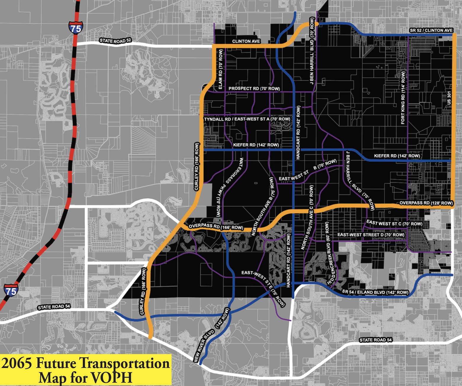
In the 2065 Future Transportation Map shown above, the roadways in orange — which include Curley Rd., Overpass Rd., U.S. Hwy. 301 and most of Clinton Ave./S.R. 52 are all planned to be expanded to six lanes. The roadways in blue — including New River Blvd., Kiefer Rd., what we have been calling the Zephyrhills Bypass (which currently ends at the eastern end of the Chapel Commons community), Handcart Rd. and the eastward extension of Eiland Blvd. (from east of Handcart Rd.) are all planned to be four-laned. And, all of the roadways shown in purple on this map — some of which already exist in some form while others don’t at all yet — are all planned as two-lane roadways criss-crossing VOPH.
Speaking of those improvements, final plans were recently completed by the county to extend Handcart Rd north from where it currently ends at Prospect Rd, thru Villages C & D, to connect up to SR 52. This extension will serve as a primary backbone for the proposed community of Harvest Hills.
Of course, all of these improvements are planned by 2065 — 40 years from now — and while many of the planned two-lane roadways are likely to be developer-built roads, we have no way of knowing how soon any of these improvements will be in place.
All those of you who live in Epperson, Watergrass, Bridgewater, Chapel Pines, Chapel Crossings, etc., or have kids attending any of the schools along Curley Rd. or on Wells Rd. know is that the traffic on Curley Rd. and S.R. 54 already is brutal and isn’t likely to get better anytime soon.
And, speaking of schools, while Metro Development told us for our previous story that the Kirkland Ranch K-8 School, the Kirkland Ranch Academy of Innovation high school and the Innovation Preparatory Academy K-8 school are all located just inside the border of the Connected City, they all appear to be in VOPH, as is Watergrass Elementary (as well as the future Pasco Public Library in Watergrass.
And, although the VOPH “special land use plan” calls for as many as seven school sites within the VOPH boundaries — and we’re assuming the four previously mentioned schools are part of that total, since the pan was originally approved 16 years ago — only one additional school site has so far been proposed in VOPH.
That proposed school, which was only added to the Pasco School District’s plan in June of this year, is at the very northern tip of Village B, at S.R. 52 in San Antonio. Whether that school will be an elementary, middle or high school or a K-8 school has not yet been determined.
To be continued.


No comment yet, add your voice below!