Research by Joel Provenzano
One of the debates that has raged for at least ten years in our area has been over the boundaries of the community we love — Wesley Chapel.
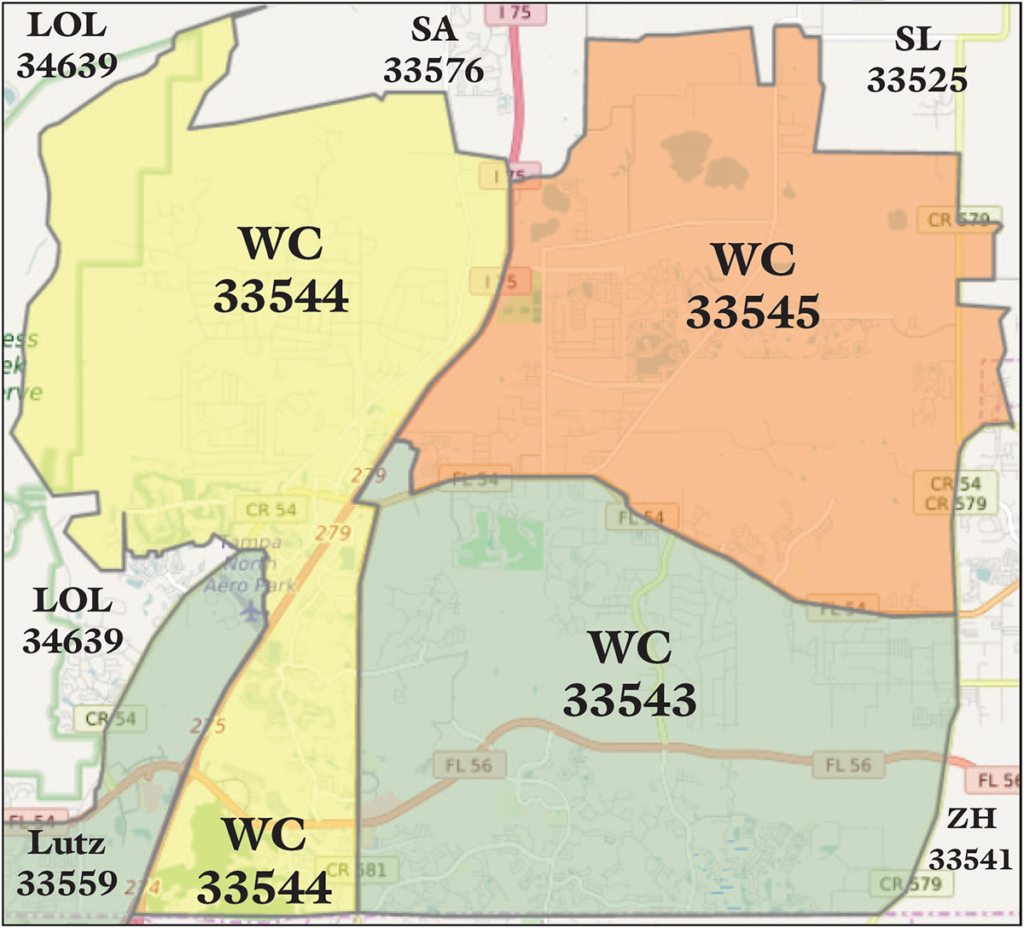
According to us, and how we direct-mail this publication, Wesley Chapel has, for nearly 30 years now, included only the communities within zip codes 33543, 33544 & 33545. The mail delivery of all three of those zip codes is still handled by the Zephyrhills Post Office, even though most of Wesley Chapel is 20-30 minutes (or more) from it. Our version of Wesley Chapel now includes more than 33,000 homes, apartments and businesses and, according to the Post Office, a little more than 90,000 people.
However, our editorial researcher and current Realtor (with Florida Executive Realty in Tampa Palms) Joel Provenzano, who previously was a transportation engineer with the Florida Department of Transportation (FDOT), says that the zip code map on this page isn’t the only way to determine the boundaries of Wesley Chapel.
In fact, Joel was put smack-dab in the middle of this controversy ten years ago when, as part of his job with FDOT, he was responsible for placing a road sign that said simply “Wesley Chapel” on the east side of Wesley Chapel Blvd., a little bit north of S.R. 56.
The problem was that since the zip code of the land upon which the sign sat was in Lutz’s 33559 zip code (as is everything west of I-75 on both sides of S.R. 56, including the Tampa Premium Outlets, see map), our friends from Lutz basically insisted that FDOT remove the sign — which today no longer sits at that location.
However, Joel says that although the zip code in that area says Lutz, the U.S. Census Bureau’s list of Census Designated Places (CDPs) includes portions of both Lutz and Land O’Lakes within its Wesley Chapel boundaries (see map, left). Interestingly enough, there also are portions within zip codes 33543, 33544 & 33545, which is what I always have called “Wesley Chapel proper,” that aren’t included in the Census Bureau’s Wesley Chapel CDP. In fact, according to the 2020 U.S. Census, the population within the boundaries of the Wesley Chapel CDP was only about 60,000 people, because of the communities that are and are not included in the CDP boundaries.
So, depending upon whose boundaries you use, one person’s Wesley Chapel is another person’s Lutz and vice-versa.
Although the name “Wesley Chapel” seemed relatively new to those of us whose families haven’t lived in this area since before “The Chap” became one of the fastest-growing communities in the U.S., according to the super-interesting book Images of America: Wesley Chapel by historian Madonna Jervis Wise, the name “Wesley Chapel” actually dates back to before the Civil War and much of the land that today is known as Wesley Chapel was at one time owned by a land trust headed by none other than the financier John D. Rockefeller.
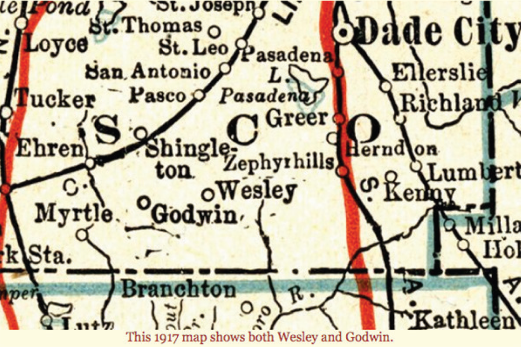
Although it became more commonly known as “Wesley,” as shown on the map below from 1917, Wesley Chapel was a small community located due west of Zephyrhills and east of the adjacent town of Godwin. It extended south basically to the Pasco/Hillsborough county line, where it met up with the community of Branchton, or what we more commonly refer to as New Tampa today.
(Source: History of Pasco County: Wesley Chapel,
Fivay.org, Aug 2020)
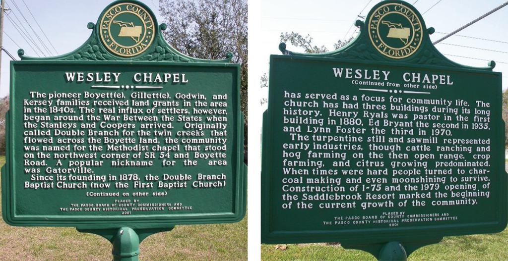
In fact, according to a map in Wise’s book, most of the area west of what is now called Old Pasco Rd. likely wasn’t considered part of the original town of Wesley Chapel as, dating back to the 1840s, the property owned by four families — the Boyett(e), Gillett(e), Godwin and Kersey families (see marker signs below) — only encompassed the area between Old Pasco Rd. to the west, the county line to the south (when all of what is now Pasco County was considered to be part of Hernando County), “Over Pass Rd.” to the north and Handcart Rd. to the east were included in the homesteads of those families.
But, in the mid-1900s, several other ranch/farming families ended up buying up most of the land the Rockefeller-Weyerhauser Trust owned, including 15,000 acres purchased by James Barney Porter, the father of James H “Wiregrass” Porter, in 1937.
But, it wasn’t until former publishing magnate Tom Dempsey purchased (around 1979) a few hundred acres on the south side of S.R. 54 (which was, at the time, nothing more than a two-lane country road that connected New Port Richey on the west side to Zephyrhills on the east side) to develop into Saddlebrook Resort (which opened in 1981) that anyone other than those ranching old timers really used the name Wesley or Wesley Chapel at all.
The only other part of Wesley Chapel already developed before Saddlebrook was Williamsburg, a small community with still fewer than 300 single-family homes that was originally intended (in the 1970s) to be a retirement community to be called “Levittown Florida,” after developer Abraham Leviitt, (and his sons), who developed the original (and much larger) Levittown on Long Island, NY.
Fast forward almost two decades later, as other portions of the former ranch lands in Wesley Chapel began developing (beginning with Meadow Pointe in the early 1990s), the name Wesley Chapel still didn’t really catch on. In fact, the first shopping center built in Meadow Pointe was called “The Shoppes at New Tampa,” as the developers tried to capitalize on the more-developed and better-known community located south of the county line. The shopping center’s name was changed to “The Shoppes at New Tampa of Wesley Chapel,” as people who lived in the newly burgeoning community north of the county line resented being referred to as “New Tampa.”
Is it Lutz Or Wesley Chapel?
But, the reason there’s even a story to tell here is primarily because the developers and the businesses located within those developments had different goals than the people who already lived in those areas.
The greatest example of this had to do with the long-awaited construction of the Cypress Creek Town Center, which is located west of I-75. To that end, the mall and all of the businesses that have popped up around it have Lutz zip codes, even though those businesses often referred to themselves (and still do) as being located in Wesley Chapel. This problem was definitely exacerbated by the fact that not only did many of the people who lived in the more rural Lutz not want their community to become part of the sprawl they saw happening in Wesley Chapel, there also were two chambers of commerce serving that area — the Greater Wesley Chapel Chamber (which was renamed and rebranded as the North Tampa Bay Chamber, or NTBC, in 2018) and the Central Pasco Chamber (which was renamed the Greater Pasco Chamber, or CPCC).
The Central Pasco Chamber fought along side the long-term residents of Lutz to not only prevent anything located in a Lutz zip code from being considered part of Wesley Chapel, they also resented that what had long been referred to as “Old C.R. 54” being renamed Wesley Chapel Blvd., and that the sign saying “Wesley Chapel” had been placed on property with a Lutz zip code.
But, according to both our editorial researcher Joel Provenzano, who worked for the Florida Department of Transportation (FDOT) at that time, and Hope Kennedy — who was the president and CEO of the former Wesley Chapel Chamber who now holds the same titles with the NTBC — neither of them had anything to do with the sign being placed at that location.
“FDOT put the sign where it was on Wesley Chapel Blvd. because the U.S. Census Bureau said that everything east of Old 54/Wesley Chapel Blvd., was part of the Wesley Chapel Census Designated Place (or CDP),” Joel says. “In fact, the Census Bureau never recognized that the community of Lutz, which was historically only part of Hillsborough County, as even extending north of the Pasco County line. The Pasco portions of Lutz are part of the Central Pasco CCD, or Census County Division.”
In other words, just as the people who lived in Wesley Chapel didn’t want to be part of New Tampa, the people of the Pasco-based portions of Lutz did not want to be thought of as Wesley Chapel, no matter what the Census Bureau, the county or the State of Florida thought about it.
In fact, Hope says she remembers when the Central Pasco Chamber tried to not only get the name “Wesley Chapel Blvd.” removed from the roadway that currently provides some of the zip code boundaries between Lutz, Wesley Chapel and Land O’Lakes, but also from the Wesley Chapel Blvd. extension that one day will extend to the Pasco-Hillsborough county line (as we reported in the Feb. 12, 2016 edition of the Wesley Chapel Neighborhood News), with new developments already planned in that area (that we plan to update you about in a future issue).
The Central Pasco Chamber and Lutz community also fought against a plan for Wesley Chapel to incorporate as its own city that never gained enough traction to be brought before the Pasco Board of County Commissioners (BCC). Hope says that part of the reason that idea failed was because neither side could get the county to come to an agreement as to what areas the boundaries of the “City of Wesley Chapel” should include.
Hope also says that she was told that the Census Bureau tries to use “natural” boundaries whenever possible to create census tracts, but even that methodology failed when it came to establishing the Wesley Chapel CDP.
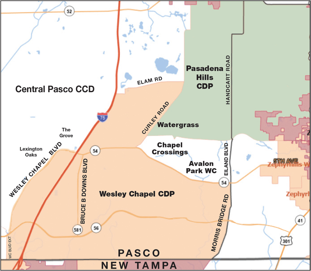
Although it is not shown on the map above, Cypress Creek runs from south of where I-75 meets the Pasco-Hillsborough county line, to the north and slightly to the west of Wesley Chapel Blvd. But, if Cypress Creek was used to establish the Wesley Chapel CDP boundaries, Lexington Oaks and The Grove, which have Wesley Chapel zip codes, would be included within its boundaries, instead of in the Central Pasco CCD (see map).
Speaking of not being included, also not within the boundaries of the Wesley Chapel CDR are Chapel Crossings and New River Township/Avalon Park Wesley Chapel. At our press time, we had no idea why these Wesley Chapel communities are not included in the Wesley Chapel CDP.
We also were surprised that other communities located north of S.R. 54 and east of Curley Rd., especially Watergrass, are considered by the Census Bureau to be part of the Pasadena Hills CDP. I always thought of Pasadena Hills as being more of a Zephyrhills-area development, with most of the CDP located east of Handcart Rd./Eiland Blvd., and had no idea that Watergrass was considered part of it, even though Watergrass does extend all the way east to Handcart.
The exclusion of these large-scale developments from the Wesley Chapel CDP boundaries explains why the Census Bureau believes there are so many fewer residents — 60,000 compared with our zip code count of just over 90,000 in 33543, 33544 & 33545.
What it unfortunately doesn’t clarify is where the boundaries of Wesley Chapel really are or should be. So, I admit that this article has been something of an exercise in futility, even though it definitely has been an extremely interesting one — at least to yours truly.
To be continued!

No comment yet, add your voice below!