
Some Neighbors In Meadow Pointe Adjacent To The New Development Have Concerns About Flooding, Noise & More
Introduction by Gary Nager
Story by Joel Provenzano
Although some locals still firmly believe that the area needs a Trader Joe’s market even more, there’s no doubt that the beginning of construction of our area’s first and only Whole Foods market is among the most hotly anticipated new developments in Wesley Chapel.
Some of the long-term residents who live in the adjacent Meadow Pointe I community, however, aren’t necessarily as excited. They’re wondering, when it comes to development, how close is too close?
With Whole Foods now under construction, some of those neighbors are voicing their concerns to the Neighborhood News.
These neighbors in The Savannahs subdivision of Meadow Pointe I are asking a number of questions, including one big one:
If a man-made retention pond was built as an original feature of a community’s design and has been part of your backyard since 1992, don’t you have the right to assume that the pond was there to stay?
Why would anyone assume otherwise? In our area, it is virtually unheard of that ponds near established community homesites would end up being removed.
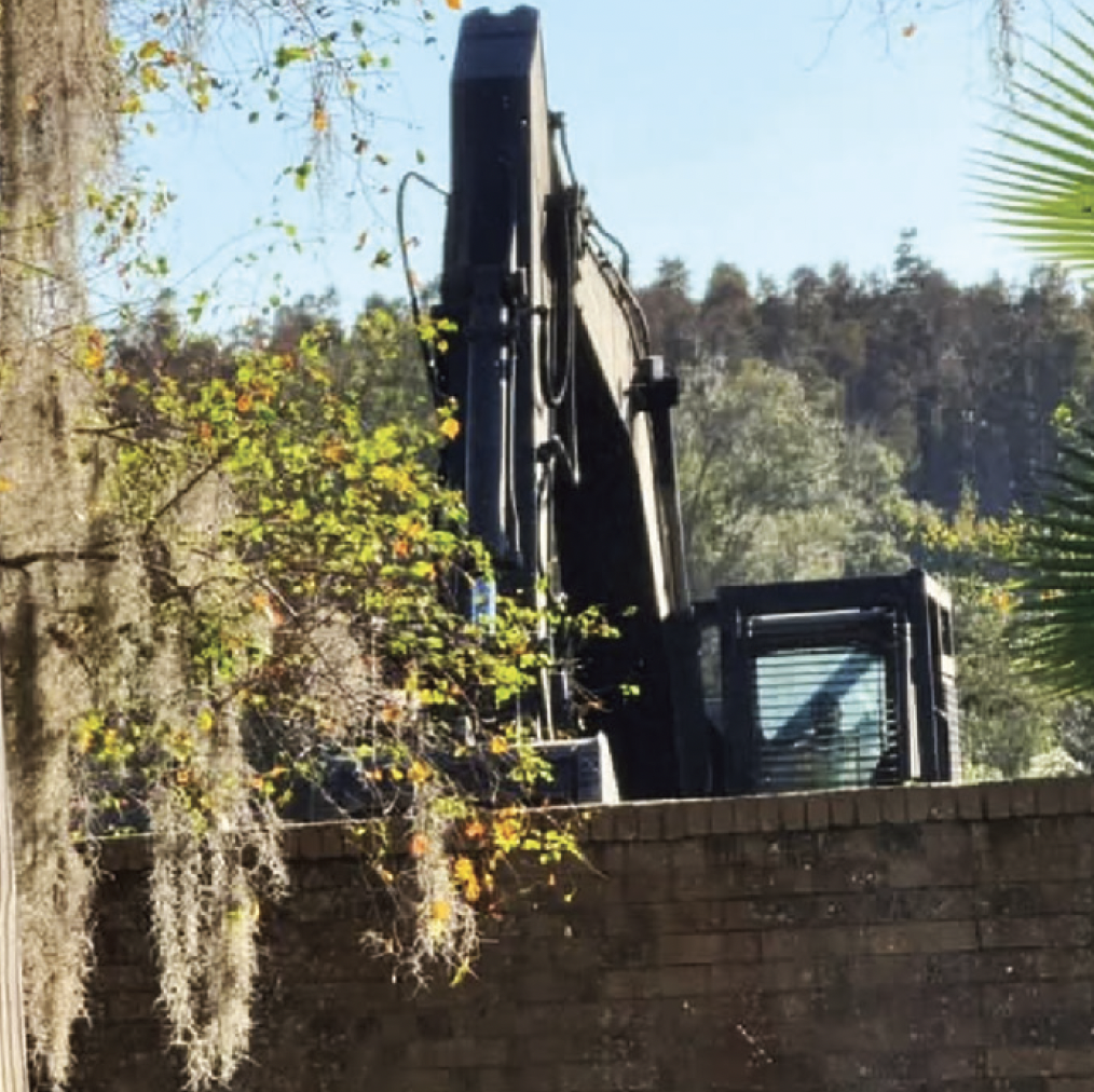
But, there is a pond located behind the homes on Openfield Loop that is being removed for this new commercial development — despite multiple failed previous attempts to develop the 16-acre property located north and east of the intersection of Aronwood Blvd. and Bruce B. Downs (BBD) Blvd. into a full-fledged commercial site — and the fact that no previous developer had proposed removing the pond.
All of the neighbors we spoke with understood that the land would eventually be developed into a neighborhood commercial site, as it has been zoned for that purpose since before their homes were built adjacent to it.
What these homeowners could not have anticipated, however, was that the latest developer (SJC Ventures) would propose moving that development even closer to their backyards by eliminating the natural buffer the pond provided — anywhere from 50-200 feet, depending upon which lot your house was located.
And that, the homeowners told us, is where the true concern lies: the edge of the parking lot would now only be 15’ from some of their backyard property lines — close enough to throw a paper airplane and hit a parked car.
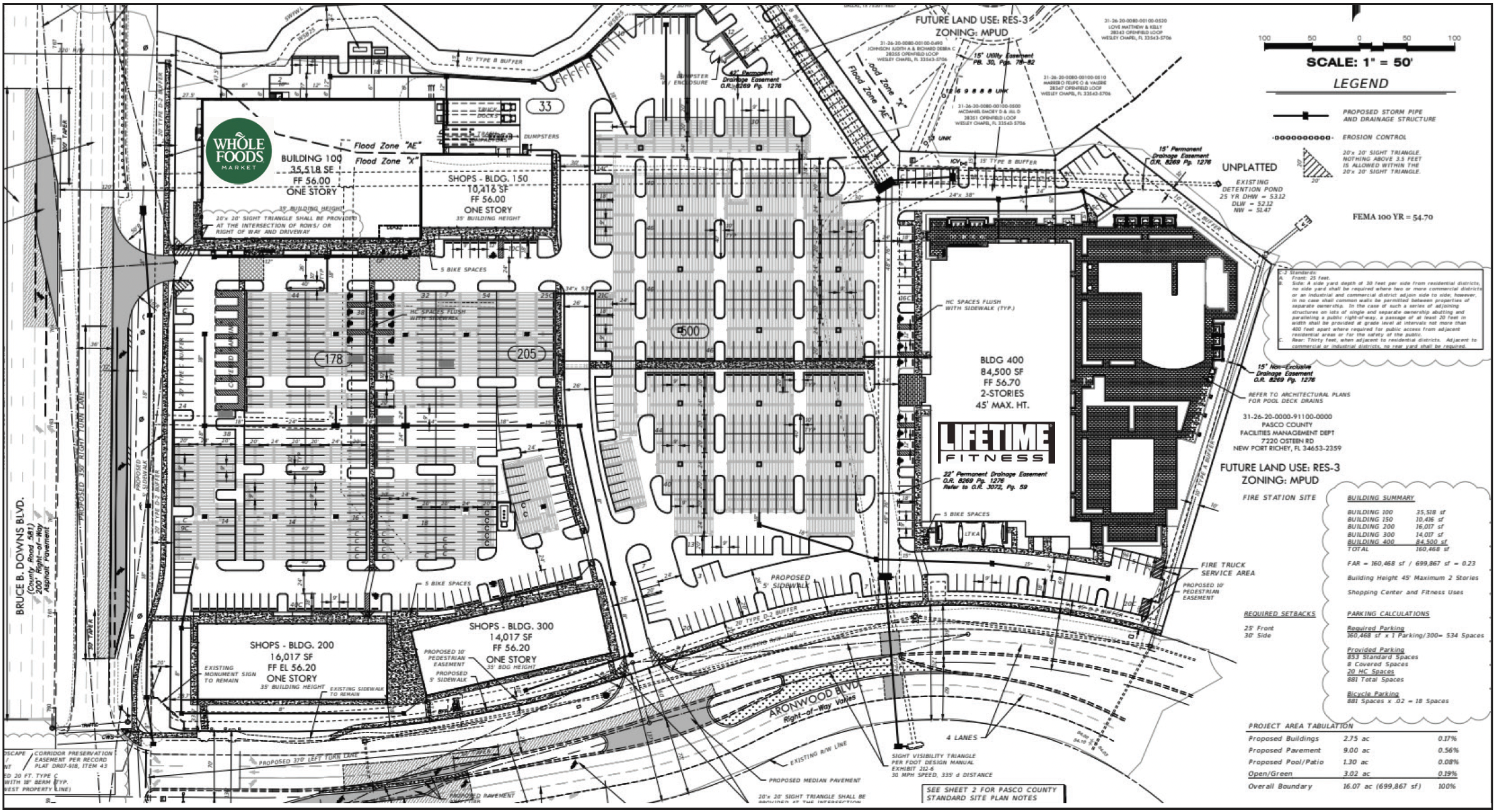
The expansive pond buffer — along with the previously approved 20-foot landscape buffer for the southernmost home, as shown in an earlier plat — are being eliminated. In its place, a standard white vinyl fence (possibly) and a uniform 15-foot buffer would directly separate six homes (see map below) from a 160,000-sq.- ft. commercial center, while the views of an additional four homes would be indirectly impacted.
Put plainly, the pond would be removed to make room for approximately 90 of the development’s 881 proposed parking spaces.
That said, the removal of existing man-made ponds for site reconfiguration does occur — just not typically in a young, rapidly growing area like Wesley Chapel, where fresh commercial developments are still popping up all over.
This type of development change normally takes place in older areas where outdated commercial developments are torn down, ponds are removed and new drainage facilities are put in place — whether that be in the form of relocated new ponds, or below-ground “vaults” to provide for more building area or parking.
It’s crazy to think that at 33 years old, and without any aged commercial development, that this parcel fits that criteria, as it is one of the oldest commercial lots (per zoning) in Wesley Chapel.
At its core, this issue reflects the broader tensions that accompany growth and development — where long-held expectations about how things were, or were meant to remain, collide with the sometimes unfortunate realities of change. It is a familiar struggle, one that increasingly places evolving commercial developer interests at odds with those of existing residents — a dynamic we have found ourselves reporting on with growing frequency.
Can more compromise and common ground be found, so everyone still gets what’s important to them?
The Developer’s Goal
The goals of neighborhood commercial development are to provide needed services and jobs for nearby residents and, of course, to make money. Having options of where to shop, where to eat and where to get health care can make an area more desirable and more enjoyable as a place to live, because people generally appreciate having proximity, freedom of choice and variety.
The affected homeowners we spoke with understand this, and wanted to make it clear that they’re not against the commercial development now under construction from SJC Ventures, but they do have some concerns.
Meanwhile, most everyone who isn’t directly abutting the property has taken to social media to let everyone know how happy they are that the area is getting the major anchor tenant:
Whole Foods — The 35,518 sq.-ft. modern grocery store owned by Amazon. As mentioned earlier, only a Trader Joe’s might have caused more excitement, but unfortunately, we spoke with Trader Joe’s corporate, which said the company currently still has no plans for a Pasco location. Many Amazon Prime members, however, are rejoicing, because of the benefits and deals offered by Whole Foods to Prime members.
Lifetime Fitness — The club is to be the second (and larger) standalone tenant. Lifetime is a slightly more upscale full-service gym that will offer everything — including two large outdoor swimming pools. Some of the homeowners we spoke with said the pools will cause additional noise and lighting at night (the Lifetime gym on Harbour Island stays open until 10 p.m. on weeknights and until midnight on weekends) that might not have been necessary if everything was fully indoors.
As gyms go, Lifetime Fitness will be quite large, offering two levels and nearly 84,500 sq. ft. of indoor floor space, plus the outdoor pools. Anyone familiar with gyms understands that this means a very large amount of parking is needed.
The Lifetime building will have a maximum height of 45’, according to the site plan. The edge of the gym building will be 92’ from the closest residential property.
The remaining property will be 40,450 sq. ft. of strip-style shops and restaurants and will include the following tenants:
PopUp Bagels — A highly rated bagel shop with existing locations in Carrollwood and the Westshore business district. Pop-Up Bagels serves hot, whole bagels with a variety of rotating shmears (cream cheeses). It’s a place for bagel purists.
CAVA — A popular quick-service Mediterranean restaurant that serves healthy food fast (ordered and made at the counter), a chain that is quickly spreading across Tampa Bay, with 10 current locations.
Naked Farmer — A very highly rated American-style “farm-to-table” quick service restaurant (ordered and made at the counter; like a more upscale Fresh Kitchen) with flavorful, healthy options. Naked Farmer has two existing locations in South Tampa, including one in the Water St. area of downtown Tampa.
Petfolk — Veterinary & Urgent Care with multiple locations across Florida.
The Tox — A popular wellness and detox spa with a highly rated location in South Tampa.
Nail Salon — Tenant TBD.
According to an SJC Ventures release, there’s still roughly 15,000 sq. ft. available. Health, wellness and wholesomeness seem to be the overarching themes for this development, with SJC expecting to have these businesses start opening in the 2nd quarter of 2027.
Digging Deeper
We had a chance to meet with many of the affected homeowners in person, and speak with them as a group. They’re all long-time residents in one household each in The Savannahs:
• Judy Johnson (8-year resident)
• Laura Knight (name she asked us to use, a 17-year resident)
• Jill McDaniel (32-year resident)
• George Ryan (32-year resident)
Each had a chance to share what they felt were their important personal issues with the project, and a few common themes emerged:
1. Flooding
2. Privacy/Security/Noise
3. Lighting
4. Setbacks/Buffers
We reached out to SJC Ventures through its general contractor (VCC Construction), and although SJC has been responsive to the homeowners, the company did not respond to our inquiry (at least not by this issue’s deadline).
However, both Pasco County and the Engineer of Record for the developer’s project, David Fauxan, did speak with us to provide some clarity about the development codes and practices being called into question by the homeowners, as well as our own technical questions.
Fauxan also has been an engineer on the original Meadow Pointe project since its conception in the early 1990s.
Amanda Hunter, a public information officer for Pasco County, says that, “The county is aware of the homeowner concerns and has attempted to address those.” However, the homeowners told us they were not impressed with the county’s communication and that no one from the county had visited with them in person, to see their concerns first hand, including:
Flooding — For the residents, the proposed removal of the pond has created concerns about flooding, especially considering that flooding during Hurricane Milton left water coming literally right up to their doorsteps (see inset photo above). The residents fear that if the pond wasn’t there, that water would have come right into their homes.
Hunter responded to the flooding concerns with the following statement: “The developer is retaining storage for stormwater under the parking lot, via a vaulted system, instead of an open stormwater pond.”
Fauxan added that the vault system would provide just as much, if not greater retention, than the pond to be removed. We confirmed that the plans do show an extensive vault system under most of the parking lot.
“Honestly, the whole site could have been a pond, and it still would not have fixed the issue,” Fauxan says about last year’s flooding. Ironically, he mentioned that the adjacent Trout Creek watershed, which goes all the way up to S.R. 54, has been strained by development over the years, changing the flood plain from what it used to be.
He added, “The flood elevation used to be ‘X’ back in 1992 (when the homes were built). But now, it’s ‘X’ + 4 feet,” meaning that the flood zone boundary actively shifted from where it used to be. “We’re raising the [project] site elevation [by up to] 2 feet because the new buildings need to be 1 foot above that new flood elevation.”
Homeowner George Ryan confirmed what Fauxan explained, saying that his home, which was previously in Flood Zone X, is now in Zone AE “per the revised boundary,” so he has to have flood insurance for the first time in the 32 years he’s lived there — and that occurred before the SJC development ever broke ground.
What does all this mean for the homeowners? Allegedly, if the area sees another Milton-like storm, which dumped 15” of rain, the water will rise again to exactly where it was after the hurricane, regardless of the pond. But, only time will tell if all of those calculations are correct.
Fauxan explained that one small improvement is planned to address existing conditions. Once a more detailed survey of the area between the residential and commercial properties has been completed, the developer intends to grade the commercial site to actively collect any water that falls near the shared property line — close to the existing wall — and redirect it into the site’s stormwater management system.
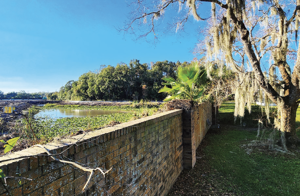
Privacy/Security — Since the pond was previously supposed to act as a natural buffer, the community only built the roughly 6-foot-tall brick wall (photo) up to the first home at the pond’s edge, where it abruptly ends. This means that three other homes will have no physical separation between them and the development’s parking lot, other than the planned landscaping.
Fauxan said that the developer intends to install a white vinyl fence to mitigate this concern, stating that the fence was shown in the development’s landscaping plans.
However, the homeowners said that, based on what they were told, the fence would be at the developer’s discretion, and a review of the August landscaping plans showed only trees and hedges along the property line, but no fence.
It’s possible the latest landscaping plans were not uploaded to the permit site.
Lighting — With a building and parking so nearby to their homes, the homeowners are concerned about lighting spilling into the properties, but we were not able to locate a light plan or a lighting analysis, so it’s difficult to analyze what those levels may be. Trees and shrubs in the buffer should help to reduce the light pollution.
Setbacks/Buffers — According to Fauxan and Pasco County, all of the project’s buffers meet the current code. But, while it’s within the acceptable threshold, is it still too close?
When we asked the county why a 30’ setback wasn’t used or why the 20’ buffer from the previous plat was reduced to 15’, the county responded: “The plat in [that question] is a reference to an older project that was not pursued. Per Table 905.2-D of the land development code (LDC), a type ‘B’ buffer is required between commercial and residential uses. A type ‘B’ buffer is 15 feet wide. Note — a landscape buffer and its width are different than a building setback, per our Zoning Code in Chapter 500 of the LDC, which is what you’ve referenced.”
In addition, “As a note, this project meets the building setback requirement. It’s not a construction setback, but a setback from a structure. The structures are set back appropriately and in accordance with the land development code.”
This means that while commercial structures must be set back at least 30’ from the adjacent residential property line, parking is permitted to be within 15’ of it, underscoring how technical compliance does not always equate to neighborhood comfort. Paper airplanes away!


