Here’s Everything Happening With Double Branch & Abbey Crossings!

Double Branch & The Adjacent Abbey Crossings To Bring New Residential, Retail, Restaurants & More To Just North Of Wesley Chapel 
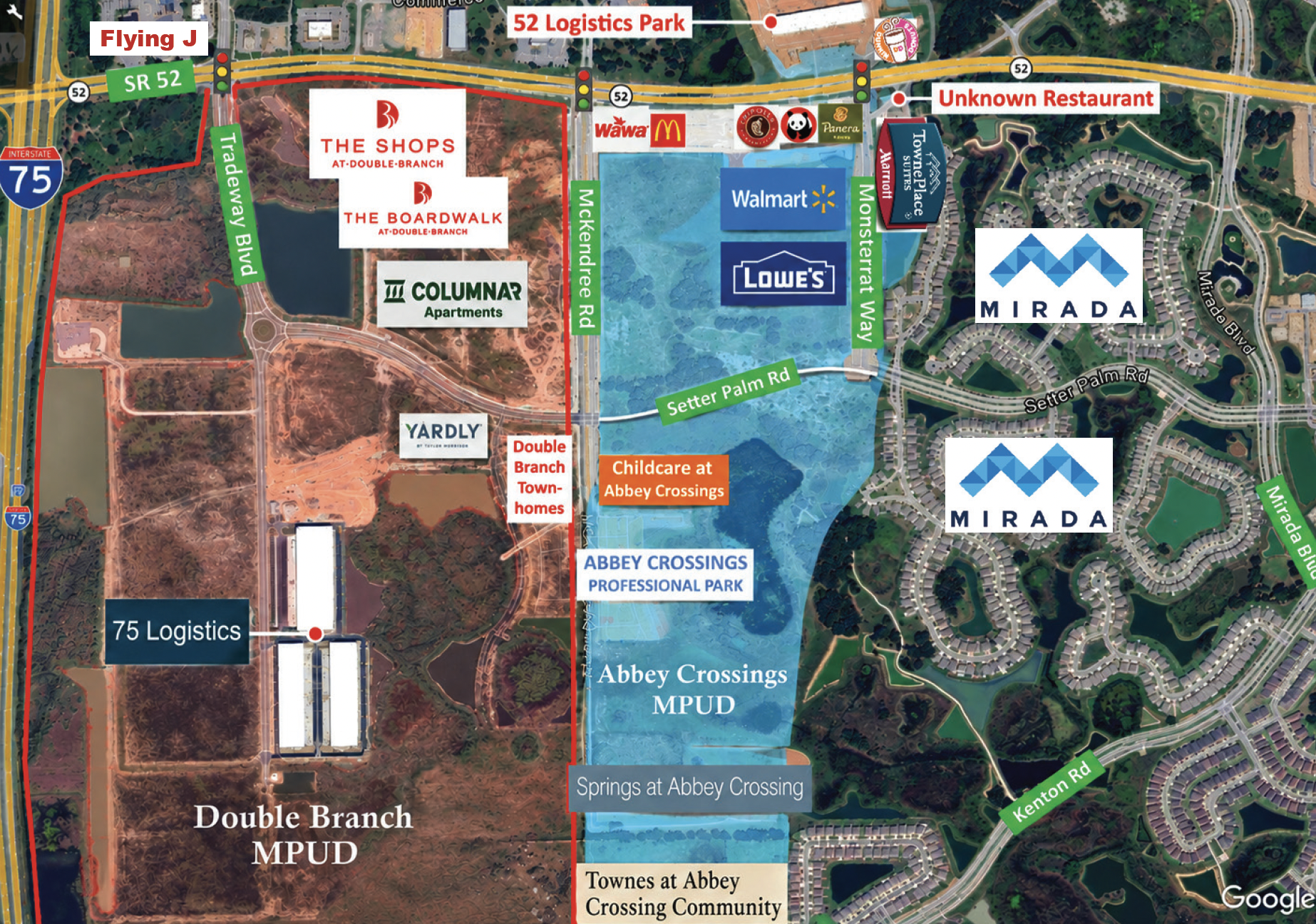
The map of the Double Branch & Abbey Crossings Master Planned Unit Developments. (Google map modified by Joel Provenzano)

 The first shells of customer-facing businesses in two new “Connected City” developments are rising from the construction sand nearly a year after the completion of the first warehouses in Double Branch and Abbey Crossings — or what seemed like an eternity in this local development climate. 

The Double Branch (and we’re not talking about the Double Branch Elementary most Wesley Chapel residents are familiar with; this is a completely different location with an entirely different purpose) and Abbey Crossings Master Planned Unit Developments (MPUDs) are beginning to really take shape. 

These two separate, yet conjoined, MPUDs are sandwiched together along S.R. 52, in the space between I-75 and the massive Mirada housing development — immediately north of Wesley Chapel (see map). 

The address for all of these new properties? Surprisingly, San Antonio, FL. 

The northern boundary of Epperson marks the end of Wesley Chapel’s 33545 zip code, putting both of these developments in San Ann’s 33576 zip code, although both are actually located (as is Mirada) in unincorporated Pasco County, outside the tiny city limits of San Antonio, which covers only 1.2 sq. miles. 

So while Double Branch (DB) and Abbey Crossings (AC) aren’t technically in Wesley Chapel, the information in this story is still helpful for readers who live along the northern edge of Wesley Chapel, where these two MPUDs — and their new dining, shopping, entertainment and employment options — will be closer to the residents of Epperson than many of the other areas of Wesley Chapel. 

And if you’re like us, you’re probably just nosy about what’s being built nearby. 

Both of these large developments (roughly 1,300 acres combined) have been talked about for several years now as important mixed-use developments for Pasco County and the so-called “Connected City,” and will both feature restaurants, retail, offices, industrial, warehouses, residential, healthcare, medical and entertainment. 

A good majority of the roads, intersections and roundabouts (at least for the initial phase) in both developments are pretty much done. 

And, three newer traffic signals are now up along S.R. 52 to serve these developments — the first was installed off the corner of the longstanding Flying J truck stop at Tradeway Blvd. (formerly Pasco Rd., which is being realigned to go under I-75), the second is at McKendree Rd., and the third serves the new warehouses located to the north at Montserrat Way.

– 75 Logistics (completed): These warehouse/industrial spaces were the first buildings to be completed in either development. Visible from I-75, the space is made up of three initial buildings: approximately 200,000 sq. ft., 155,000 sq. ft., and 125,000 sq. ft. All of the buildings still appear to sit unoccupied at the time of our writing, even though they were completed a year ago. 

– DB (for Double Branch) Townhomes (utilities in, foundations next): Currently, there’s still no official name, but it’s being referred to as the Pasco Town Center Lot E Rear Load Townhomes (w/ Amenity Center) in the permit. 

The project consists of 174 townhome lots, an amenity center with a pool and cabana, and a portion of Double Branch Pkwy. This project is within the greater Pasco Town Center master planned community inside of Double Branch and is the first of what will be two townhome communities in that immediate area, the other being Yardly Double Branch (upcoming). 

“Rear Load” means that the garages will be in the back of the units in alleyways, and some (but not all) of the units will have on-street parking in the front. The home builder is not known at this time. 

– Yardly Double Branch (plans just submitted): This rental community will feature 140 multi-family residences on around 11 acres. For those unfamiliar with the “Yardly” concept, it’s Taylor Morrison’s rental development concept, where each unit (4 units to a building) has, you guessed it, a small fenced-in yard. 

About half the units will have attached garages, but others will not. Standard parking spaces are provided throughout the community in front of each unit for guests and residents. 
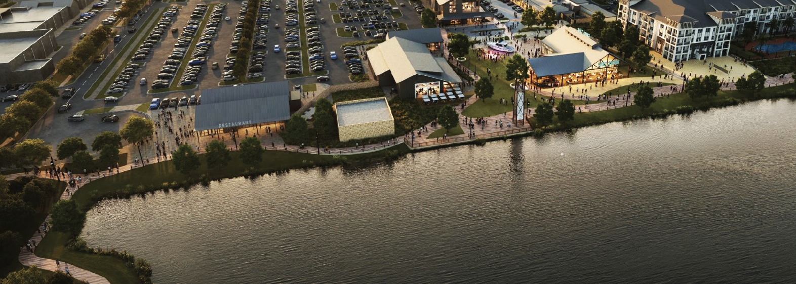
This rendering shows The Boardwalk at Double Branch wrapping around the lake. The Shops are on the far left & the Columnar Apartments are on the far right. (Source: SRS Real Estate Partners) 

– The Shops & The Boardwalk (plans submitted): This is going to be Double Branch’s much-anticipated retail zone located against S.R. 52. The concept brings something that has really been lacking from the area to take advantage of our amazing sunsets — unobstructed west-facing water views from a restaurant. This plan brings not just one, but four potential (and still unnamed) restaurants waterside along a boardwalk looking west over a huge 12-acre lake. 

Initial plans have been submitted for both The Shops and The Boardwalk; however, no specific tenants have yet been announced. In addition to restaurants, the plans also show build-out spaces for a 40,000 sq. ft. fitness center, 25,000 sq. ft. grocery store, 25,000 sq. ft. retailer, along with a host of smaller spaces and even entertainment venues. 

– Columnar Apartments (plans submitted): Located immediately south of The Boardwalk shops area, this 300-unit apartment complex will continue the boardwalk along the shore of the lake, providing a scenic walking space for its residents and direct connectivity to the adjacent retail center. 

– 52 Logistics Park (completed): This warehouse/industrial park is comprised of five buildings of different sizes that total roughly 500,000 sq. ft. The main entrance was aligned with Montserrat Way to the south to give this development direct access to the brand-new traffic signal. 

These warehouses also have been sitting empty for months; however, plans were just submitted to the county in Aug. for interior build-outs, signaling that tenants are coming soon. 

– Panera Bread (exterior walls are up): 
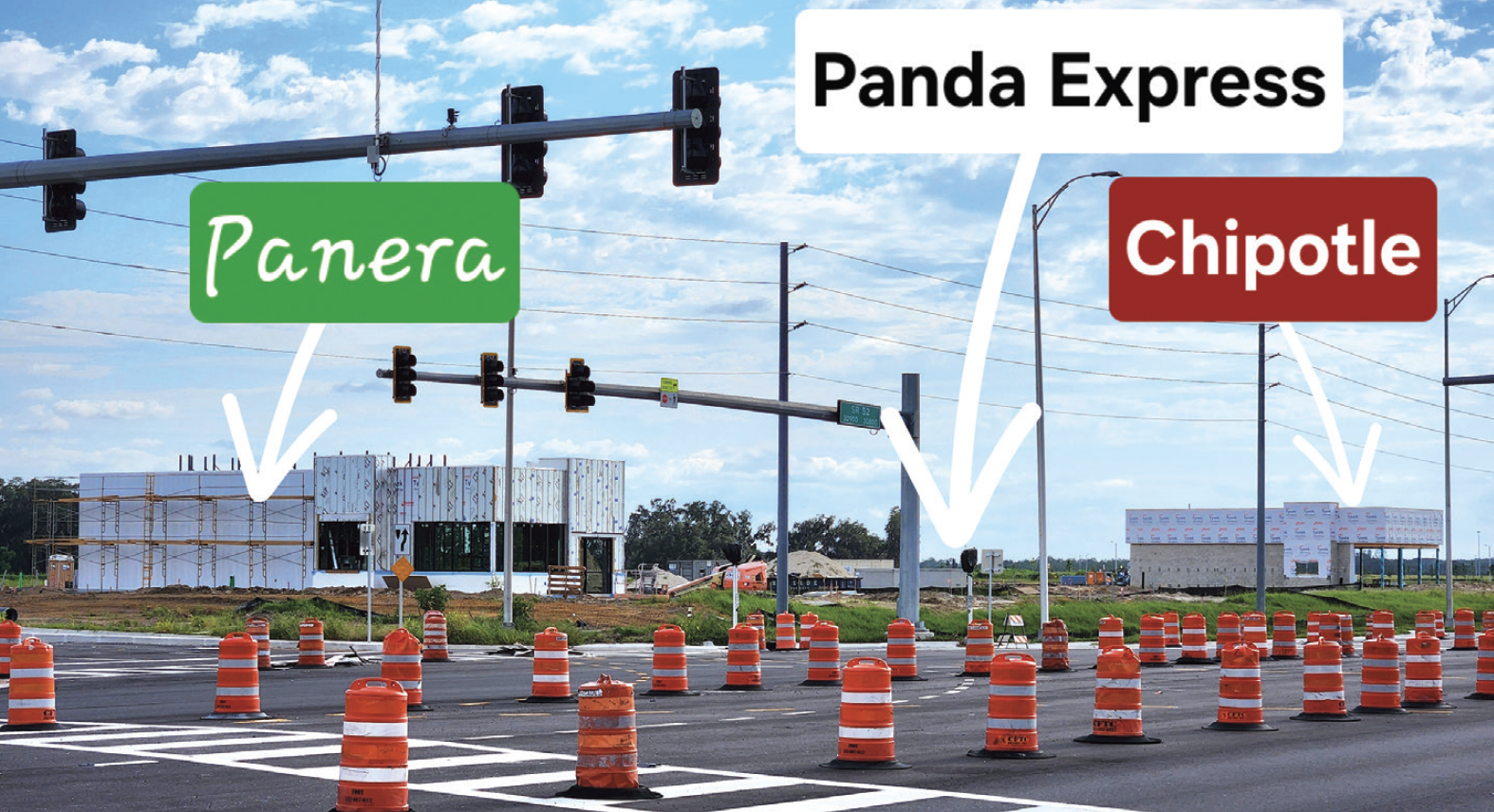
Panera, Panda Express & Chipotle are all under construction in Abbey Crossings. (Photo by Joel Provenzano)

This is being built on the SW corner of the signal with Montserrat Way. This familiar national chain will bring a free-standing store that will be smaller than what most customers are used to, at only 2,500 sq. ft., but it will have a drive-through. This is Panera’s shift to a more suburban-style prototype with smaller indoor dining areas. 

– Chipotle (exterior walls are up): Further to the west along S.R. 52 will be another national favorite that also is a free-standing location that also will feature a drive-through window, which the company calls “Chipotlanes.” 

These drive-through lanes work differently than most fast food restaurants because they’re digital-only. This means that you cannot roll up and order at a speaker board. Customers must place their order in advance using the Chipotle Mobile App or website. Because food is prepaid and pre-made, cars generally spend less than 30 seconds at the window. 

Chipotlanes have become highly successful for the brand, and they expect 80% of all newly built locations to feature a drive-through. 

– Dunkin’ Donuts (exterior walls are up): This free-standing store with a drive-through is going up at the NE corner of SR 52 and Montserrat Way, adjacent to the signal. The familiar favorite is being positioned so that residents can easily get their coffee on the way out to I-75. 

– Abbey Crossings Professional Park (exterior walls are up): These are being advertised by Waterford Construction & Development as ‘Custom Free-standing Offices’ that will be both for sale and for lease. The park will be comprised of 23 free-standing, single-story office and medical/dental professional buildings. Individual office spaces are planned around 3,000-5,500 sq. ft. max per building, with the ability to divide. 

– Wawa (plans submitted): Plans have been approved for a new Wawa to be built at the southeast corner of S.R. 52 and McKendree Rd., adjacent to the newer traffic signal. The gas station will feature 16 fueling positions and be one of the largest stores in the area at over 5,600 sq. ft., which will serve I-75 travelers well. 

– McDonald’s (plans submitted): McDonald’s and Wawa will share a driveway onto S.R. 52. The McDonald’s also is anticipated to be a larger size than what most customers are used to at nearly 3,900 sq. ft. and will feature a long double-stack drive-through queue that can easily accommodate around 25 cars, something more commonly seen with a Chick-fil-A than with a McDonald’s. 

– Panda Express (plans submitted): This American Chinese food favorite will be located directly between the Panera Bread and Chipotle. The stand-alone 2,700 sq. ft. building will feature double order boards and two queue lanes for the drive-through window, something we’ve never seen before at a Panda Express. 

– Townplace Suites by Marriott & Restaurant (plans submitted): Suncoast Hotels LLC has submitted a site plan application package for the Abbey Hotel & Restaurant development, which is planned to be a Marriott by info found on the Suncoast Hotels website. 

The project will be at the southeast corner of the signal with Montserrat Way, and consists of the construction of a 63,284-sq.-ft. hotel and a 10,000-sq.-ft. restaurant (no name announced yet) on a 5.7 acre parcel. 

– Walmart (plans submitted): A new Walmart is planned in Abbey Crossings just south of the new signal, directly behind where the new Panera Bread and Chipotle are being built. 

For those who are having déjà vu and remember our recent article about another new Walmart planned to be built in Wesley Chapel, this one will be considerably farther away — 15 miles from the one at S.R. 56 & Morris Bridge Rd., and 9 miles from the existing store at C.R. 54 & Wiregrass Ranch Blvd. 

In our article about that Wesley Chapel Walmart, we mentioned that the retailer likes to space its stores approx. 8-9 miles apart in populated areas, so this new store continues that trend to the north. 

– Lowe’s (plans submitted): Just south and immediately adjacent to Walmart, along Montserrat Way, is a proposed Lowe’s home improvement store. 

What’s odd here is that San Antonio is going to be getting a Lowe’s before Wesley Chapel does. Those who follow our development news may remember that both of the previously proposed Wesley Chapel Lowe’s locations — one at C.R. 54 & Curley Rd. and the other at S.R. 56 & Morris Bridge Rd. (where the new Walmart is going), were withdrawn. 

– Childcare at Abbey Crossings (plans just submitted): Being done by Momentum Childcare LLC, this 12,000-sq.-ft. facility is planned to be constructed on the east side of McKendree Rd., just south of Setter Palm Rd. The site will feature considerable outdoor fenced space consisting of two playgrounds, an outdoor theater, a garden and an outdoor classroom. 

– Springs at Abbey Crossing (plans submitted): Located fairly far south down McKendree on the east side, this proposed 20-acre apartment complex will consist of 330 units and will feature a few more amenities than normally seen in an apartment complex, including a pool, pet playground area, pickleball court, cornhole court, bocce ball area, fire pit and hammocks to just lay under the sun or stars. 

– Townes at Abbey Crossing (platting complete): Located immediately south of the Springs at Abbey Crossings apartments, on the east side of McKendree Rd., the Townes will consist of 150 townhomes, with Lennar Homes as the builder. 

– Del Taco (withdrawn): Del Taco was previously proposed and announced on the northwest corner of the Montserrat signal across from the Dunkin’ Donuts. Plans were submitted exactly a year ago but were withdrawn by the developer last December, unfortunately canceling the project. 

Del Taco doesn’t currently have a presence in Tampa Bay, with the closest location being in Spring Hill. Customers describe Del Taco as a fresher alternative to Taco Bell. A recent review of Pasco permits does not show any other proposed locations at this time, so we’ll have to wait and see if Del Taco decides to add a store somewhere else. 

Where Are The Villages Of Pasadena Hills & Why Should You Care?

Research by Joel Provenzano 

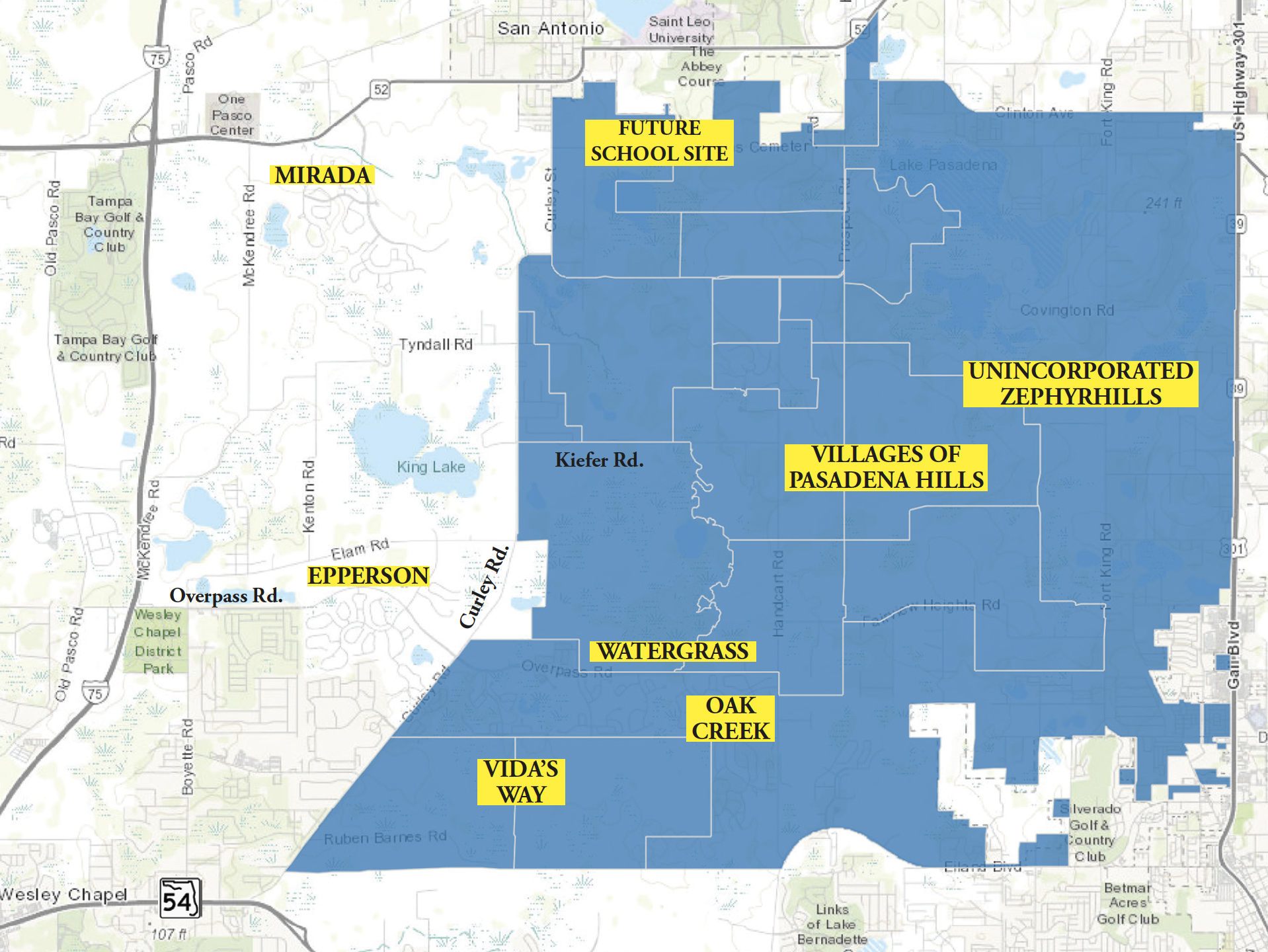
The map above shows the outline of the 20,000+-acre Villages of Pasadena Hills (VOPH) & the approximate, relative positions of Epperson, Mirada, Oak Creek, unincorporated Zephyrhills & more. This is a portion of the Pasco County GIS map, which was modified by NN, as we also added clearer labels for S.R. 54, Overpass Rd., Curley Rd. & Kiefer Rd. This map is also somewhat dated, however, because it doesn’t show the reconfiguration of S.R. 52, although that reconfiguration is shown in the map at the bottom of the page. Please also note that the locations of all markings added by NN are approximate and are not to scale. 

Over the past several months (and for years before that), we’ve written a lot about Pasco County’s so-called “Connected City,” a “special land use plan” established the State of Florida in 2015 that already is increasing the size of the Wesley Chapel area by thousands of residences and millions of square feet of commercial uses. 

But, not only is the Connected City not alone in Pasco in having a special land use plan, there is another such plan — first established in 2008, and implemented by Pasco in 2009, or six years before the state helped Pasco create the Connected City. 

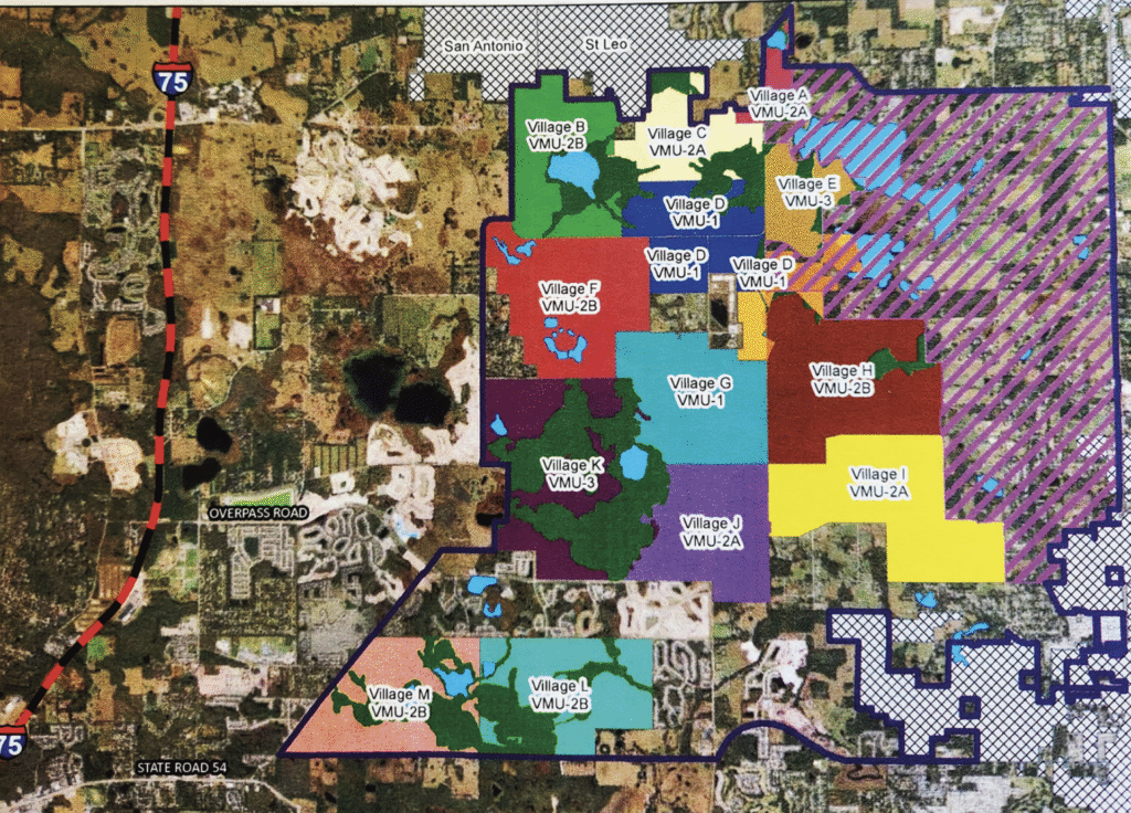
This special land use plan is called The Villages of Pasadena Hills (VOPH), but most Wesley Chapel residents know very little (if anything) about this huge, 20,000+-acre (see top map on this page) land use plan that includes 13 planned villages designated by letters A-M (map below). 

“Pasadena Hills” is actually its own “Census Designated Place” — with a 2010 population of more than 7,000 people — some of whom are located in Wesley Chapel. 

The Wesley Chapel residents in that number live primarily currently in the 1,162 residences in the Watergrass community north and south of Overpass Rd. and east of Curley Rd., but also in the smaller Oak Creek community, which is just south of Watergrass on the Wesley Chapel (west) wide of Handcart Rd. 

But, a lot of those current VOPH residents live east of Handcart Rd. in Zephyrhills, including in the communities of Stonebridge, Hidden Creek and Silverado. The northern boundary of VOPH also touches S.R. 52 and includes a portion of San Antonio and extends to south of the incorporated town of St. Leo. 

The only community in VOPH that currently has homes being built is Vida’s Way, which we first told you about several months ago. This Pulte Homes community currently has its 305-home Phase 1 in development, with approximately 300 more in Phase 2, in VOPH Villages L&M (near the bottom of the bottom map, right), but there is a lot more to come. 

The map above shows VOPH’s 13 distinct “Villages” (lettered A-M), as well as the area with purple lines designated as “Countryside Area.” The under-development community called Vida’s Way will encompass parts of Villages L&M near the bottom of both maps. 

Among the planned communities coming soon to VOPH are two Lennar developments in Village F, one called Twinflowers, with 129 single-family (SF) homes and 60 townhomes, and the other called Acacia Fields, with 204 SF homes. Both of these new subdivisions are located off the existing Tyndall Rd., which is in the VOPH plan to be expanded and connected from Curley Rd. on the west side and east to Handcart Rd. 

Also getting ready to build in Village F is Magnolia Island by Homes by WestBay, on the north side of Kiefer Rd., which also is planned to extend from Curley Rd. to Handcart Rd. Magnolia Island is planned to include 269 SF and 120 townhomes. 

Two additional communities are getting ready to build in VOPH. One is Chapel Manor by KB Homes, which will be 146 SF homes located east of Handcart Rd. in Village G, which will have Zephyrhills addresses. 

Also to be located in unincorporated Zephyrhills will be Pasadena Ridge, by Homes by WestBay, which will build another 579 SF homes in Villages G&H. 

In all, that makes 2,112 home sites to be added in VOPH in the near future and all of these new communities — except Phase 1 of Vida’s Way — were just finalized over the summer. Many more communities are being proposed and/or are going through the permitting phase in VOPH, which has entitlements for 41,987 total residential units, 2,260,000 sq. ft. of commercial entitlements and 500,000 sq. ft. of office entitlements. Among those additional developments are: 

Harvest Hills South, which is located in Village H, is proposed to include around 300 homes, both SF and townhomes, near Prospect and Handcart Rds. 

Depue East MPUD, located in Village L, is planned for 931 acres and could include up to 1,700 single-family homes, 300 townhomes, 300 apartments, and 20,000 sq. ft. of commercial space. 

There also is an as-yet-unnamed MPUD proposed for Villages J, K, & G, involving 614 residential units, including 175 townhomes and SF homes, located between Kiefer Rd. and Overpass Rd., west of Handcart Rd. 

There also was a rezoning last year in Village B, with plans for 796 dwelling units and 75,000 square feet of non-residential use to be developed on 101 acres of property, but we had no further word on when this possibly community might begin building. 

We weren’t able to get confirmation of all of these planned developments from District 1 Pasco County Commissioner Ron Oakley, whose district includes all of VOPH, so we can’t say for sure which are only proposed and which are for certain moving forward. 

All of the potential residential and commercial developments are expected to be divided up among all 13 villages — which are themselves divided into four “Village Type” categories, as follows: 

Type 1 — Villages D&G — With 9,516 total residential unit entitlements and 1,320,000 sq. ft. of commercial and office entitlements between them, the Type 1 villages are the “most urban” of the villages. 

Type 2A — Villages A,C,I&J — With 11,030 total residential unit entitlements and 960,000 sq. ft. of commercial and office entitlements between them, the Type 2A villages contain all of the remaining office and much of the remaining commercial entitlements not included in the Type 1 villages. 

Type 2B — Villages B,F,H,L&M — With 17,621 residential unit entitlements and 400,000 sq. ft. of commercial entitlements between them, the Type 2B villages contain most of the remaining commercial entitlements not included in the Type 1 and Type 2A villages. 

Type 3 — Villages E&K — With 3,820 residential unit entitlements and 80,000 sq. ft. of commercial entitlements between them, the Type 3 villages only contain “neighborhood commercial” entitlements. 

It’s also important to note that roughly 1/3 of VOPH (7,000+ acres) is to be retained and designated as a “Countryside Area,” which is land that will be required to remain rural in character, and cannot be redeveloped in any substantial way. This “Countryside” area is indicated by the purple slashes on the bottom map on pg. 6 that extend from the eastern end of Village I north to the east side of Village A, all in unincorporated Zephyrhills. But again, this is the plan. It remains to be seen if Pasco will allow the plan to be altered. 

If you read (as I have) the entire 50-page document serving as the “blueprint” for the development of VOPH, it’s clear that the intent of the state and county when this special land use plan was established was to create something better than the typical Pasco County community — one with multiple modes of transportation, walkability and lots of parks and green spaces, including a planned 140+-acre “Superpark” that, as it turns out (as we reported in a previous issue) probably isn’t going to end up as a major park site, due to issues with the property set aside for it. 

According to that document, the goal of the Pasadena Hills Area Plan is to “Establish a long-term vision for the future of Pasco County that will enhance the livability of the Pasadena Hills area and that will integrate Future Land Use plans and policies with a master transportation network” in a manner that will provide: 

• A “smart growth” approach to accommodate additional growth and new development in a sustainable form. 

• Long-term mobility. 

• A logical extension of urban uses that successfully transitions to existing patterns of rural development. 

• The capital construction of services and facilities to serve the new land use form. 

The document also talks about the “Planning Framework” that Pasco is supposed to employ “to create a planning framework and implementation strategy that will enhance the livability of Pasco County and preserve its natural, cultural, and physical resources. 

Among the planning principles described in the plan are: 

• Plan for the logical extension of urban development in a more sustainable form. 

• Provide for a variety of land uses and lifestyles to support residents of diverse ages, incomes, and family sizes, including housing that is affordable to residents of Pasco County. 

• Reduce automobile trips and trip lengths. 

• Create efficiency in planning and provision of infrastructure. 

• Allocate development costs appropriately. 

• Preserve and protect existing rural enclaves. 

• Preserve and protect areas that exhibit existing patterns of rural development along Fort King Road. 

• Preserve environmental systems and functional open spaces. That all sounds great on paper, but the fear here, as it always seems to be in Pasco County, is that the people who own the land — with many of the families of the property owners having owned their land for decades — will be incentivized, whether by the county, developers or (usually) both, to abandon the very clear principles set out in the VOPH blueprint in order to maximize profitability for the property owners and tax base for the county. 

Considering just how rural the vast majority of the property in VOPH currently is, it’s kind of hard to imagine any type of “Urban Core” anywhere in those thousands of acres, much less one that will be served by an actual working roadway network — especially based on how overrun with traffic the roadways serving most of the existing master-planned communities throughout the county seem to be. 

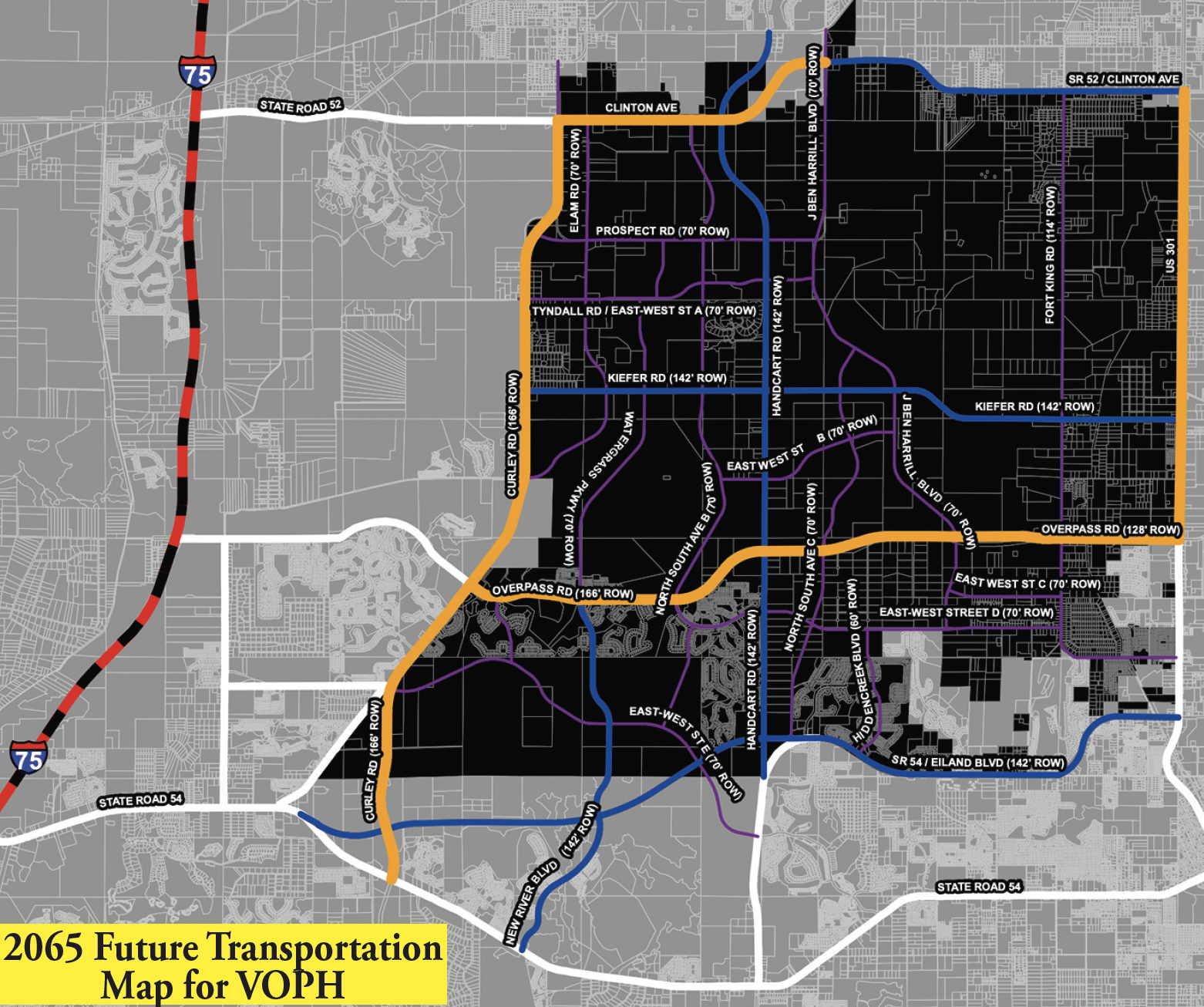
In the 2065 Future Transportation Map shown above, the roadways in orange — which include Curley Rd., Overpass Rd., U.S. Hwy. 301 and most of Clinton Ave./S.R. 52 are all planned to be expanded to six lanes. The roadways in blue — including New River Blvd., Kiefer Rd., what we have been calling the Zephyrhills Bypass (which currently ends at the eastern end of the Chapel Commons community), Handcart Rd. and the eastward extension of Eiland Blvd. (from east of Handcart Rd.) are all planned to be four-laned. And, all of the roadways shown in purple on this map — some of which already exist in some form while others don’t at all yet — are all planned as two-lane roadways criss-crossing VOPH. 

Speaking of those improvements, final plans were recently completed by the county to extend Handcart Rd north from where it currently ends at Prospect Rd, thru Villages C & D, to connect up to SR 52. This extension will serve as a primary backbone for the proposed community of Harvest Hills. 

Of course, all of these improvements are planned by 2065 — 40 years from now — and while many of the planned two-lane roadways are likely to be developer-built roads, we have no way of knowing how soon any of these improvements will be in place. 

All those of you who live in Epperson, Watergrass, Bridgewater, Chapel Pines, Chapel Crossings, etc., or have kids attending any of the schools along Curley Rd. or on Wells Rd. know is that the traffic on Curley Rd. and S.R. 54 already is brutal and isn’t likely to get better anytime soon. 

And, speaking of schools, while Metro Development told us for our previous story that the Kirkland Ranch K-8 School, the Kirkland Ranch Academy of Innovation high school and the Innovation Preparatory Academy K-8 school are all located just inside the border of the Connected City, they all appear to be in VOPH, as is Watergrass Elementary (as well as the future Pasco Public Library in Watergrass. 

And, although the VOPH “special land use plan” calls for as many as seven school sites within the VOPH boundaries — and we’re assuming the four previously mentioned schools are part of that total, since the pan was originally approved 16 years ago — only one additional school site has so far been proposed in VOPH. 

That proposed school, which was only added to the Pasco School District’s plan in June of this year, is at the very northern tip of Village B, at S.R. 52 in San Antonio. Whether that school will be an elementary, middle or high school or a K-8 school has not yet been determined. 

To be continued.

New Townhome Community In Epperson May Get An Elam Rd. Entrance After All

Residents of Abby Brooks Circle (ABC) in the Epperson II CDD met with Pasco Planning Dept. director David Engel (blue suit) and Development Services director David Allen (gray suit) during the May 6 Board of County Commissioners meeting to discuss alternatives to using ABC as the only access point to a new townhome community in the Epperson North CDD.  

Even though the county attorney’s office told Pasco County’s Board of County Commissioners (BCC) on May 6 that there was nothing they could do about Metro Development Group’s plan to put the only entrance to a new townhome community —  located in the Epperson North Community Development District (CDD), through a quiet Epperson II CDD community along Abby Brooks Cir. (ABC) — the residents who live on ABC have been encouraged by the possibility that a possible solution appears to be on the horizon.

As of today, the efforts of ABC residents Candice and Mark Alfieri, Danielle Polovich, Alexandra Lewis, Erin Totaro, the Epperson II CDD Board and many of the 120 total affected families on ABC and Lily Arbor Way — who met twice the week before the May 6 BCC meeting to put together a strategy to protect their quiet neighborhood full of children — seem to have been fruitful, as a Metro spokesperson told the Neighborhood News that the details of an agreement for a possible second entrance to the JK2 townhome community off Elam Rd. is in the works, but is not yet finalized, and released only the following statement:

“Metro has heard the concerns raised by residents regarding access for the Epperson North townhome community, and we want to assure you we are working with local officials to devise the best possible plan for everyone involved. We ask for your patience as we navigate a solution. Metro prioritizes resident safety and neighborhood connectivity. We’re committed to thoughtful planning and collaboration to ensure the long-term success of the Epperson community.”

Abby Brooks Circle (ABC) resident Alexandra Lewis was one of nearly two dozen residents living on ABC in the Epperson II CDD who asked the Pasco Board of County Commissioners for help regarding an approved entrance through their quiet street for a new townhome community in the Epperson North CDD.  

The current plan — which was approved administratively by the county staff using the State of Florida’s new Land Use Equivalency Matrix, without a BCC vote — has Elam Rd. as an emergency-only entrance to the townhome development. 

In other words, the townhome site, which was originally donated to the Pasco County School District for an elementary school, did not need a BCC vote to be rezoned for JK2’s 186 planned townhomes after the School District gave the site back to Metro and said it didn’t plan to build a school on it.

County attorney Jeffrey Steinsnyder told the commissioners on May 6 that there was nothing they could do to change the development plan, but commissioners Jack Mariano, Kathryn Starkey and Lisa Yeager all said that they supported the efforts of the two dozen ABC residents who spoke or planned to speak at that meeting. 

Representatives of the ABC group then met with Pasco Planning Dept. director David Engel and Development Services Dept. director David Allen while the May 6 BCC meeting was still taking place to see if, in reality, anything could be done to keep ABC from being the townhome community’s only (or main) entrance.

A week or so later, even though the future townhome residents currently are still planned to also have access through ABC, the main entrance to the JK2 community could now be shifted to Elam Rd., which is much more capable than ABC of handling the additional (estimated) 1,000 or more trips per day the 186 townhomes are expected to generate. 

Look for another online update as soon as any agreement is finalized, as well as a fully updated story in the June 10 edition of Wesley Chapel Neighborhood News.


Pasco Seeking Park Site In Connected City; Plus, Epperson II Townhome Concerns 

Although the meeting happened a little more than a month ago as you’re receiving this issue, there were two important new pieces of information that came out of the presentations about the 7,800-acre “Connected City” (CC) development made to the Pasco Board of County Commissioners (BCC) by Metro Development Group principal Kartik Goyani and the county staff on Apr. 9. 

The first had to do with the number of single-family entitlements still available in CC. William Vermillion of Pasco’s Planning & Economic Growth department, who oversees MPUDs in Pasco, said that a recent study by the county found that there are still 44% of the single-family detached home entitlements left in CC. 

“Even though you were told a couple of years ago that there were no more single-family (SF) entitlements left,” Vermillion said, “there actually are still about 4,400 remaining [of the 10,583 SF homes originally approved for CC]. We also have about 50% of the multi-family, which includes townhomes and garden-style homes for the higher density areas. We also still have roughly 37% of our commercial left and 75% of the office. And, we have roughly 26% of the land remaining.” 

Dist. 2 Comm. Seth Weightman told me after that meeting that although he was shocked the staff had been giving the commissioners the wrong figure for so long, he didn’t believe the “mistake was intentional on anyone’s part. We’ve had a lot of turnover in our staff.” 

But, had Comm. Weightman known there were still SF entitlements available, would he still have voted to allow other developers within CC to convert their plans from SF to multi-family (MF)? 

“No, I would not have voted to convert them [to MF] had I known the correct figures,” he said, adding that he remembered that one of the conversions he reluctantly voted for, “felt like chewing on a mouthful of sandspurs.” 

As for CC’s current Park Service Areas, Vermillion said on Apr. 9 that if you combine “all of the parks in [CC], there are 115 acres of neighborhood parks already built, not inclusive of the planned VOPH (the adjacent Villages of Pasadena Hills development) Superpark or the Wesley Chapel District Park” (neither of which are in CC). 

But, Weightman noted that the 240-acre (previously reported as 300-acre) VOPH Superpark, “isn’t going to be as ‘super’ as we anticipated. We’re going to fall short on a few areas of uses, and, with the age of the people moving to the area growing younger, I really feel we need to revisit the diverting of [CC] funds to the VOPH Superpark.” 

He added, “With the [WC] District Park already at capacity, we need to find a way to have a similar style park within [CC] and whether we reallocate funds from the shortfall that the Superpark is going to have, or we restructure the way that funding mechanism works, I think it needs to be done because [CC] is here today. The youth and their parents are demanding that we have field space now for a variety of sports. The people are here now, so the 40 acres we have in the site we [Pasco] already owns [in CC]…that footprint needs to be doubled and we need to figure out the funding between VOPH and [CC] because something needs to happen sooner than later in the [CC} corridor.” 

Pasco Parks Dept. director Keith Wiley then responded that Comm. Weightman was correct. 

“And, the question is,” Wiley said, “Where should we locate the other park facilities in [CC]? We’d have to ‘swap’ projects in order to have a district park, since a community park doesn’t really get it done. We’d have to decide which of the 21 capital projects identified need to be removed.” 

Board chair & Dist. 3 Comm. Kathryn Starkey said she would like Wiley to look into using the site Pasco owns near the future CC Town Center Hub, either for a land swap or to build a District Park on property that had originally been slated for a utilities maintenance area. 

Wiley added, however, that the county’s Master Parks Plan was done more than a decade ago and could be updated, “rather quickly” to see if there are locations within CC that could accommodate a District Park. At our press time, we had not heard if that update had been completed. 

Dist. 1 Comm. Ron Oakley, whose district includes CC, cautioned, however, that the entire county needs more ball fields, not just the [CC], “and we can’t build more parks without having the money to maintain them.” 

On May 1, I attended a meeting of the Epperson Ranch II Community Development District (CDD) Board of Supervisors, which is, “the only CDD in Epperson that has no parks and no amenities whatsoever,” said CDD Board chairman Joseph Murphy (as well as several of the 50 or so Epperson II residents in attendance during the three-hour meeting). 

“And the site in Epperson II that previously was designated as a school site has been rezoned for 186 townhomes and the one entrance and exit for that townhome community is now Abby Brooks Circle (see map), which is a quiet, residential neighborhood that can’t handle the 400 additional vehicles per day from those townhomes. The entrance to that townhome community should be off Elam Rd., which is already a main road through Epperson, and which was designated as the entrance to the school site. But, when the property was converted to townhomes, the Board of County Commissioners agreed to change that to only allow emergency vehicles to access the townhome community using Elam Rd.” 

The Epperson II residents who spoke at that CDD meeting all voiced their displeasure, concern and fear for the safety of their children if the townhome community was able to proceed with the plan to use Abby Brooks Cir. as its only ingress and egress point. Although the next BCC meeting was on May 6, two days after we went to press with this issue, the residents shared with me a resolution drafted by the CDD’s new lawyer, Jere Earlywine of Kutak Rock, which was sent to every commissioner on May 2, asking that the BCC reconsider its decision to not allow regular vehicular access to Elam Rd. and to commission a new traffic study — since the previous study was conducted in 2015, when the townhome site was still a school site. 

The CDD resolution says, “…In order to protect the health, safety, and welfare of the [Epperson II] District and its residents, guests, and constituents, the Board hereby declares its objection to the proposed change of roadway configuration for the Former School Parcel, specifically as it relates to authorizing a single point of ingress and egress to and from the Former School Parcel, and without a primary access from the Former School Parcel to and from Elam Road. The Board hereby directs District Staff to transmit this Resolution to Pasco County, Florida, and respectfully requests that Pasco County take all appropriate action to rectify the improper change of roadway configuration for the Former School Parcel, to conduct and/ or re-conduct a traffic study in order to determine the impact of the anticipated traffic on the existing roadways and residents of Epperson Ranch II CDD, and to modify and/or revoke any development approvals related thereto.” 

The only Epperson II CDD supervisor to vote against drafting and sending the resolution to the BCC was Mike Lawson, who also is the only CDD supervisor who works for Metro. Lawson is the director of operations for the CC developer. 

The BCC didn’t have anything about Epperson II on its May 6 agenda, so no action could be taken, but the residents of Epperson II, particularly those who live on Abby Brook Cir., were planning to show up at that meeting in force to again express their concern, this time to the county commissioners. 

We’ll keep you posted.

Commissioners Get ‘Connected City’ Updates

Editor’s Note – The original version of this story appeared in our Apr. 15 Wesley Chapel issue, which went to press before Metro Development Group and the Pasco County Planning Department staff held a presentation for the Pasco Board of County Commissioners (BCC) at the BCC’s regular meeting on Apr. 9.

The purpose of that presentation was to update the commissioners on the progress of both the 7,800-acre Connected City (CC) development — which Metro calls “The First Smart Gigabit Community in the U.S.” — and the adjacent Villages of Pasadena Hills (VOPH) planning area.

And, despite what some critics are claiming, Metro principal Kartik Goyani says that CC, which was approved as a Pilot Program for the entire state and by Pasco in 2015 and began development with Metro’s Epperson community in 2017 — is only in year eight of a 50-year plan and, in his estimation, the CC development is proceeding according to plan.

Goyani provided an overview of the overall CC project — how it came to be, Metro’s part in it and the progress of the project itself — for the commissioners.

“I’m here to represent everyone who’s part of the Connected City planning area,” Goyani said as he began his presentation. “Your staff  said to me, ‘Why did we even create the [CC]? Well, that was 10 years back, so maybe it’s time to go back and see what was the goal and was it a good idea all along? I don’t have all the answers, so I’m going to do my best to walk you through the journey we went on…and the thinking behind it.” He also said that the need for the presentation to the BCC started, “with the chatter online” (more on this below).

Goyani first showed the boundaries of the Connected City planning area (see map).  The orange lines on the map, which Metro provided to me for my original version of this story, indicate the boundaries of what is called CC, of which only the western boundary follows a specific roadway — I-75.

The northern boundary extends to a little north of S.R. 52 in San Antonio, with several important commercial developments and yet another (as yet unnanounced) AdventHealth hospital to be located in this northernmost section. (Note-Goyani told me when I interviewed him for the original version of this story that AdventHealth has owned that property since 2019 or 2020.) 

“But, it wasn’t the S.R. 52 we drive on today,” Goyani told the commissioners. “It wasn’t the four-lane divided highway. It was two lanes, undivided and it kind of jogged, [and that part is now] C.R. 52.” 

Curley Rd. forms most of the CC’s eastern border, although a portion of it extends east of Curley — between Elam Rd. to the north and just north of the eastern portion of Overpass Rd. to the south. It is worth noting that the Watergrass community, which includes property both north and south of that eastern extension of Overpass Rd., is not part of CC.

And, speaking of Overpass Rd., everything north of it from I-75 to the entrance of Epperson is within the CC boundary, but that boundary also extends south of Overpass to include all of the Epperson development, but not the pre-existing Palm Cove or Bridgewater communities.

Goyani also reminded the commissioners that there was no exit off I-75 at Overpass Rd. when CC first started and Curley Rd. was just two lanes. “And, at that time, the discussion kept coming up, mostly led by the then-county administrator (Michele Baker), based on an Urban Land Institute (ULI) study that the county had commissioned during the last downturn in 2008, which was, ‘We need jobs in Pasco County,’ which at that time, was a bedroom community (for Tampa), with ULI estimates of 70,000 cars heading south every day — and something needed to change.”

He added, however, “There was only one problem at that time. We only owned 900 acres in Epperson (with 3,000 residences), and 2,000 acres in Mirada (with 4,500 residences), which is only about 40% of the land and 20% of the planned residences in [CC}. And, just to set the stage — we had our entitlements and approvals already. We could have just built a regular community, with the cookie-cutter housing which none of you like. Or, we could change.”

He then noted that the “Connected City” name is just a placeholder, but the idea was, “Why don’t we create a new town from the internet up that becomes an economic engine that attracts the jobs and gets the healthcare and the fiber connectivity. And, the $14 billion [transportation] funding shortfall that everyone is talking about…maybe ask those private guys to pay up a little bit more than what they were paying in impact fees. Great idea, but no one is going to come to this area unless we put it on the national and international map.”

And, Goyani said, “Everyone we met with said, ‘Why do something only for two projects — meaning the land we had?’ Let’s do something bigger, which is what led to creating this 7,800-acre ‘Special Planning Area.’ The county had laid the foundation for this type of area, having already approved a long-term plan for [VOPH} to the east of [CC].”

In other words, Goyani said that although Metro’s intent, when the CC pilot program was approved by the state in 2015, was to have the CC connected by both high-speed internet and walkways and multimodal transportation opportunities, the developer’s primary focus was the internet.

“From a fundamental standpoint,” he said, “counties and developers usually focus on the physical infrastructure — roads, water lines, waste water, electrical, because you can’t have a community without those — but no one else was working on the digital infrastructure. That’s how this story ended up evolving.”

As for CC’s physical infrastructure, Goyani said that when CC began development, no other developers were interested in improving S.R. 52 or creating an Overpass Rd. interchange off I-75. “But, by bringing [CC] to Pasco, S.R. 52 is now vastly improved and the Overpass Rd. intersection is open, meaning that the physical infrastructure for [CC] is now in place. That is a big reason why we have been able to attract so many employment centers to this development.”

Regarding parks and trails, Goyani told the BCC, “I can only speak to the parks and trails that we do in our communities. But, we worked with [county] staff to create the 50-year master plan with the goal being that people [other developers in CC] are going to carry this thinking forward and hopefully make it better.”

And, although some current CC residents (see below) say it’s not enough, Goyani showed the BCC photos of golf carts, jogging paths and tot lots for kids. He also noted that the Wesley Chapel District Park already existed at that time just to the south of CC and the county had set aside land for its 300-acre “Superpark” in VOPH, just east of CC.

“The Board made the great decision at that time to take all of the funds for parks in [CC} and put it towards the Superpark to create a truly regional destination.”

He also said that the average home in CC pays $4,687 in additional impact fees for infrastructure, schools and technology, and those fees have raised “a total of more than $30 million in additional impact fees to date.”

Goyani also mentioned, both to me and at the Apr. 9 meeting, that, “Back when we first started planning [CC ] in 2013, we looked at the amount of new commercial construction for all of Pasco County and I believe the total amount from east to west at that time was only 300,000 sq. ft.

“So, as we started laying out the goals for our 50-year plan. Our goal was to see at least 3 million sq. ft. of commercial over the 50-year plan for the Connected City,” Goyani said. “But, as we started talking, we felt that was too small of a goal, so why not plan to do something — in one small area — that’s 50 times what the entire county does in one year? That’s how we ended up with a goal of 12.8 million square feet. “

He also said that last year, Metro commissioned a study by PFM Financial Advisors LLC out of Orlando, which showed that Pasco is now “the fastest growing commercial corridor in Florida. There is now 36+ million sq. ft. of non-residential uses in different stages, which is more than any other county in the state of Florida, and I’m like, ‘Wow, that is exciting. Maybe we’re onto something here. If I were to bet, I’d say we’re going to run out of commercial entitlements throughout the Connected City because I think more is still going to happen, based on the plans.”

Another major commercial project within CC is the Double Branch/Pasco Town Center, a 965-acre mixed-use project just east of I-75 at S.R. 52 that is already under development and will include up to 4.5 million sq. ft. of industrial space at its build-out. Phase 1 of that project, which is expected to begin delivering finished buildings later this year, includes three industrial buildings totalling nearly 500,000 sq. ft. There also are plans for 1 million sq. ft. of office space, a 1.6.-million-sq.-ft. distribution center and a 400,000-sq.-ft. “cross-dock facility,” which is a logistics hub designed for the rapid transfer of goods to minimize storage time. Double Branch is being developed by Columnar Investments, which also is planning to have 500,000 sq. ft. of retail uses, 3,500 residential units and 200 acres of parks and trails.

Some of the other privately owned portions of CC also have commercial entitlements (or are asking for them from the county), such as the Abbey Crossings/Park 52 Logistics piece that will bring 500,000 sq. ft. of light industrial uses to north of S.R. 52 and neighborhood commercial and a hotel to south of 52. 

I’ll admit that the non-residential CC numbers shocked me. They include not only the Johns Hopkins All Children’s Hospital that just broke ground in the Wildcat-Bailes property in CC’s southwest corner (see separate story on pg. 8), but also the not-yet-announced AdventHealth hospital just north of S.R. 52, as well as a large BayCare medical office complex that will not only help staff the expandable BayCare Wesley Chapel Hospital a few miles south of CC, but also focus on wellness to help people in CC live healthier and longer.

Also located on the outskirts of CC is the Kirkland Ranch Academy of Innovation, which started in 2022 with a high school and now also has grades K-8. Two years earlier, Innovation Preparatory Academy (aka InPrep), a charter school, opened for the 2020-21 school year and Prodigy at Epperson Early Learning Center is now open south of the CC border just south of InPrep.

Goyani ended his presentation to the BCC citing the following figures: 

“The 2065 (50-year) goal for residences in CC was 37,345, with more than 19,000 (51%) already built. The non-residential goal was 12.8 million sq. ft., and nearly 12 million of that (93.5%) has already been approved. There also is another 1.7 million sq. ft. of commercial in areas adjacent to CC.” 

The county’s presentation on Apr. 9 started with William Vermillion of the Planning & Economic Growth department. Vermillion, who oversees MPUDs in Pasco, said that a recent study by the county found that there are still 44% of the single-family detached home entitlements left in the Connected City. 

“Even though you were told a couple of years ago that there were no more single-family entitlements left,” Vermillion said, “there actually are still about 4,400 remaining [of the 10,583 SF homes originally approved for CC]. We also have about 50% of the multi-family, which includes townhomes and garden-style homes for the higher density areas. We also still have roughly 37% of our commercial left and 75% of the office. Industrial entitlements are shown as 0% remaining because of the Double Branch development, which originally opted out of [CC] because they wanted more industrial entitlements than what was originally contemplated. And, we have roughly 26% of the land remaining.” 

Dist. 2 Comm. Seth Weightman told me that although he was shocked the staff had been giving the commissioners the wrong figures, he didn’t believe the “mistake was intentional on anyone’s part. We’ve had a lot of turnover in our staff. But no, I would not have voted for the conversions from single-family to multi-family in Connected City had I known the correct figures.” He remembered saying that one of the conversions he voted for, “felt like chewing on a mouthful of sandspurs.”

Vermillion also showed an SPA (Special Planning Area) checklist for CC with green check marks next to the items that are proceeding according to the CC’s comprehensive plan and red dashes for those that aren’t, in each zone. 

“We can see that the North Innovation Zone is accomplishing what was set out in the comprehensive plan,” Vermillion said, “including commercial, retail and single-family detached, hotels, medical and civic uses.”

Moving on to the South Innovation SPA Zone, Vermillion said, “The dash mark next to the high-density multi-family in that zone is only speaking to the fact that the comprehensive plan for [CC] doesn’t directly prescribe what, in fact, high-density multi-family is. There is already multi-family approved in MPUDs within the South Innovation Zone. However, because the [CC] comprehensive plan doesn’t prescribe the density range for that high-density, we felt it was worth noting that to the Board.”

As for the Community Hub SPA zone, Vermillion said, “There are two red dash marks, the first being for cultural. It’s worth noting that, in both the Tall Timbers MPUD that’s going to be coming before you next month and in the Kenton Rd. MPUD, there are conditions of approval which encourage public art that can serve that focus that’s spoken to by the Community Hub. And, that dash by “Civic” uses, while there are no currently approved civic uses within the Community Hub zone, just to the south, within Watergrass, we did allocate a 7-acre library site which can accommodate those residents for that civic use.”

And finally, Vermillion said that in the two highest density and intensity SPA zones — the Business Core and Urban Core zones — the [CC] comp plan is being met and “Mr. Kartik did a great job of addressing all of the non-residential land uses within these two SPA zones.”

Vermillion also noted a county study from 2023 of the volume of traffic on S.R. 52. “That explosion happened once we finally started having development within [CC], post-Covid, from 2020 until now, but despite that spike, no road [in CC] exceeds the current [volume] threshold acceptable by the county. In other words, the infrastructure is keeping up with the number of entitlements that are being approved within [CC].”

As for CC’s current Park Service Areas, Vermillion said if you combine “all of the parks in [CC], there are 115 acres of neighborhood parks already built, not inclusive of the VOPH Superpark or the Wesley Chapel District Park.” 

But, Weightman noted that the 240-acre VOPH Superpark, “isn’t going to be as ‘super’ as we anticipated. We’re going to fall short on a few areas of uses, and, with the age of the people moving to the area growing younger, I really feel we need to revisit the diverting [of CC] funds to the VOPH Superpark. With the District Park already at capacity, we need to find a way to have a similar style park within [CC] and whether we reallocate funds from the shortfall that the Superpark is going to have, or we restructure the way that funding mechanism works, I think it needs to be done because [CC] is here today. The youth and their parents are demanding that we have field space now for a variety of sports. The people are here now, so the 40 acres we have in the site we [Pasco] already own…that footprint needs to be doubled and we need to figure out the funding between VOPH and CC because something needs to happen sooner than later in the [CC} corridor.”

Pasco Parks Dept director Keith Wiley then responded that Comm. Weightman was correct.

“And, the question is,” Wiley said, “Where should we locate the other park facilities in [CC]? We’d have to ‘swap’ projects in order to have a district park, since a community park doesn’t really get it done. We’d have to decide which of the 21 capital projects identified need to be removed.”

Board Chair & Dist. 3 Comm. Kathryn Starkey said she would like Wiley to look into using the site Pasco owns near the future Town Center Hub, either for a land swap or to build a District Park on property that had originally been slated for a utilities maintenance area.

Wiley added, however, that the county’s Master Parks Plan was done more than a decade ago and could be updated, “rather quickly” to see if there are locations within CC that could accommodate a District Park.  

Dist. 1 Comm. Ron Oakley, whose district includes CC, cautioned, however, that the entire county needs more ball fields, not just the [CC], “and we can’t build more parks without having the money to maintain them.”  

Prior to the Apr. 9 meeting, I also spoke with Realtor® and CC resident Michael Pultorak, whom we have featured in these pages before. Pultorak created the Facebook group known as the “Pasco Connected City Residents Group (PCCRG).” The group quickly built up to 1,600 members, as he and the group members have consistently appeared at Pasco BCC and Planning Commission meetings to ask questions and/or complain about the way CC is being developed, even though many of the concerns expressed have been about the development plans of some of the CC land owners other than Metro.

Pultorak has already met with four of the five commissioners to discuss his concerns, some of which below do also revolve around Metro’s portions of the development. And, some of these concerns were addressed on Apr. 9, but others were not:

• The open space & recreational areas detailed in the CC Master Plan have been moved to east of Handcart Rd. (outside of the CC boundaries) 

• The walking/jogging trails promised to Mirada and Epperson residents were not delivered and the trails were not in the engineering plans nor created in the execution of the development

• The innovative lagoons are private and for-profit amenities

• There are no promised cultural facilities or libraries of any kind yet planned in CC

• Stormwater concerns at the head of the Cypress Creek watershed with upcoming CC development applications

• King Lake (a 263-acre lake and the largest body of water in CC) flooding issues for current CC residents. (Note – Pultorak says that King Lake has been beyond flood stage since Metro began digging the nearby Epperson lagoon)

• Planned roadways within CC that topographical maps show will be under water

• No schools actually located within the CC boundaries (Goyani said that InPrep and Prodigy actually are within the CC boundaries)

• The large park planned to be within CC has been moved to the adjacent VOPH

• Multi-family apartments and townhomes being approved by the Pasco BCC that are in portions of CC that, according to the Master Plan approved by the state, should not be allowed

• The approved plan for the five Special Planning Area (SPA) Zones within CC has not been adhered to by Pasco, especially with regards to approvals for multi-family apartments

“We are not against responsible growth and development,” Pultorak said. “However, developers need to be held accountable to the residents of Pasco County to fulfill the promises they make before they take profits and move on or unexpectedly cause flooding of existing residents and communities. That’s why we formed this group.”

Many of the concerns outlined above were presented in our previous story about CC, when the Planning Commission first voted to send the Tall Timbers MPUD on to the BCC for final approval. After giving the nod to Tall Timbers 4-3 on Jan. 9, however, the Planning Commission then voted 6-1 at the same meeting to put a one-year moratorium on all future CC development agreements, site approvals, building permits and zoning changes. 

But, since the Planning Commission is only an advisory panel, the final say on both Tall Timbers and any possible CC moratorium still lies with the BCC. Those votes were originally supposed to be held at the BCC meeting on Feb. 11, but the discussions and votes have now been continued twice — first to Mar. 11 and now until the BCC meeting on Tuesday, May 6.

But, while Goyani still can’t speak to what the other CC land owners are doing, his primary response to most of the complaints is that, “We are only still in year eight of a 50-year plan. We knew before we started that it would be hard to make everyone happy with this unique development but we believe — and we are proud — that we are helping to put Pasco County on the map with [CC].”    

 ‘Connected City’ Developer Responds To Critics 

Metro Development Group Principal Kartik Goyani Says The Unique Community’s 50-Year Plan Is Right On Track In Year 8 

 With Wesley Chapel already growing by leaps and bounds, the area known as the Connected City (CC) — conceived by Metro Development Group as a partnership with Pasco County and approved by the State Legislature as a “special planning area” pilot program for the State of Florida — is something completely unique. 

Rather than just another collection of developers building nothing but more of the same subdivisions that Pasco seemingly will continue to approve until there is no more vacant land within the county’s nearly 750 total square miles, Metro Development principal Kartik Goyani says that, when it comes to CC, there is a 50-year plan in place to be more than just another series of individual developments of single-family homes, apartments and retail strip centers. 

Despite what some critics are claiming, Goyani says that CC, — aka the “First Smart Gigabit Community in the U.S.,” which was approved in 2015 and began development with Metro’s Epperson community in 2017 — is only in year eight of that 50-year plan and, in his estimation, the 7,800- acre CC development is indeed proceeding according to plan. 

Before we get into the discussion of what is or isn’t happening in CC, here are some geographical facts, many of which may not be 100% clear from the map (above), which was provided to us by Metro. 

The orange lines on the map indicate the boundaries of what is called CC, of which only the western boundary follows a specific roadway — I-75. 

The northern boundary extends to a little north of S.R. 52 in San Antonio, with several important commercial developments and yet another (as yet unnanounced) AdventHealth hospital to be located in this northernmost section. Goyani says AdventHealth has owned that property since 2019 or 2020. 

Curley Rd. forms most of the CC’s eastern border, although a portion of it extends east of Curley — between Elam Rd. to the north and just north of the eastern portion of Overpass Rd. to the south. It is worth noting that the Watergrass community, which includes property both north and south of that eastern extension of Overpass Rd., is not part of CC. 

And, speaking of Overpass Rd., everything north of it from I-75 to the entrance of Epperson is within the CC boundary, but that boundary also extends south of Overpass to include all of the Epperson development, but not the pre-existing Palm Cove or Bridgewater communities. 

Of course, knowing the boundaries of CC doesn’t really give you any insight into why Metro Development decided to create a massive employment center where people could live, work and play in a portion of Pasco County that was super-rural, not even suburban, when Metro first proposed the idea of the CC to the county and the state in 2014. 

According to Goyani, it all started with internet speed. He says that before the Covid- 19 pandemic hit in 2020, the last economic slowdown was in 2008, but as business started to pick back up in 2009-10, Pasco County’s goal was to transform the county from a sleepy bedroom community, with thousands of residents leaving the county to work in Tampa, into a thriving self-sustaining economic center of its own. 

And, even though other developers may not have been thinking about how to plan for a better future, Goyani says, “We knew from our own experience during the 2008-09 downturn, that before the next downturn hits, we wanted to offer something that it seemed no one else was even interested in — faster internet. So, in 2014, we launched Ultrafi (Metro’s own bundled internet and cable service with ultra-fast internet speeds, up to 10 Gigabits per second) in our Park Creek community in Riverview and planned to include it in Epperson (the first development in CC).” 

He says that “everyone asked us ‘Why are you focusing on something that technology companies should do? No one’s asking us for faster internet, because they only have one connected device at home.” 

Goyani’s response is that, “We knew that to retrofit a community for faster internet would be very expensive. So, we laid fiber lines everywhere that could get insanely fast speeds at prices we all can afford. We talked to Google fiber (which wasn’t interested in Pasco County), AT&T, Verizon…and they all said no one wants faster speeds, so we did it ourselves.” 

He adds, “Could we use technology for the greater good? Could we create a new community from the internet up?” 

In other words, although Metro’s intent, when the CC pilot program was approved by the state in 2015, was to also have the CC connected by walkways and multimodal transportation opportunities, the developer’s primary focus was the internet. “From a fundamental standpoint,” he says, “counties and developers usually focus on the physical infrastructure — roads, water lines, waste water, electrical — because you can’t have a community without those, but no one else was working on the digital infrastructure. That’s how this story ended up evolving.” 

But, speaking of physical infrastructure, Goyani says that when CC began development, no other developers were interested in improving S.R. 52 or creating an Overpass Rd. interchange off I-75. 

“But, by bringing the CC to Pasco, S.R. 52 is now vastly improved and the Overpass Rd. intersection is open, meaning that the physical infrastructure for the CC is now in place. That is a big reason why we have been able to attract so many employment centers to this development.” 

He also notes that while most large-scale developments at that time were offering huge 10,000-20,000-sq.-ft. clubhouses or “amenity centers” that were intended to provide the community’s “social infrastructure,” Metro saw that during the last economic downturn, “people had to decide between being able to afford their mortgage or paying for the maintenance of a 20,000-sq.-ft. clubhouse for the use of the residents only. That just didn’t make sense to me.” 

Goyani says he wanted to create something that could benefit the entire region, “that’s why we put the first Metro Lagoon® in the U.S. in our Epperson community. Nobody was putting these lagoons in a community. We felt that connecting the digital, physical and social aspects — and the ‘Wow’ factor of the lagoons — would help put Pasco County on the map.” 

He also says that Metro didn’t even own all of Epperson. “We only own the southern half,” he says. “But we did own Mirada, where we put the second CC lagoon amenity (that is roughly twice the size of the lagoon in Epperson, and the largest such lagoon in the U.S.; photo above right).” He also said that the two lagoons in CC have attracted 1.2 million people combined since they opened. 

One of the problems for Goyani and Metro is that the 900-acre Epperson community, with roughly 3,000 residences at buildout, and the 2,000-acre Mirada development with 4,5000 residences, represent less than 40% of the 7,800 acres and only about 20% of the planned residences in the CC, so a lot of the CC plan approved by the state and county is not under Metro’s control. 

Putting the number of residences aside, among the things Goyani is most proud of with the CC is the amount of new non-residential square footage that is planned, especially when it comes to health care. 

“Back when we started planning the CC,” Goyani says, “we looked at the amount of new commercial construction for all of Pasco County and I believe the total amount from east to west at that time was only 3000,000 sq. ft. So, as we started planning for the future, the county administrator told us that he wanted to see at least 3 million sq. ft. of commercial over the 50-year plan for the Connected City. Back then, I thought that was unreasonable, with only 300,000 sq. ft. under construction for the whole county, but I agreed that if we’re going to create an economic engine for Pasco, we have to look forward.” 

He adds, “We started talking to the stakeholders in the area and said, ‘This is a 50-year plan and we need to set up large areas where we can get people both living and working and over time, that 50-year goal went from 3 million sq. ft. to 12 million. And, if we could get that done by 2065, everyone would probably be happy, right? But, do you know how many sq. ft. of non-residential is already under development in CC? How does 8 million sq. ft. sound? And, it’s all already approved, having groundbreakings…with real dollars being spent, in 2025.” 

I’ll admit that number shocked me. It includes not only the Johns Hopkins All Children’s Hospital that just broke ground in the Wildcat-Bailes property in CC’s southwest corner, but also the aforementioned, not-yet-announced AdventHealth hospital just north of S.R. 52, as well as a large BayCare medical office complex that will not only help staff the expandable BayCare Wesley Chapel Hospital a few miles south of CC, but also focus on wellness to help people live healthier and longer. 

Another major commercial project within the CC is the Double Branch/Pasco Town Center, a 965-acre mixed-use project just east of I-75 at S.R. 52 that is already under development that will include up to 4.5 million sq. ft. of industrial space at its build-out. Phase 1 of the project, which is expected to begin delivering finished buildings later this year, includes three industrial buildings totalling nearly 500,000 sq. ft. There also are plans for 1 million sq. ft. of office space, a 1.6.-million-sq.-ft. distribution center and a 400,000-sq.-ft. “cross-dock facility,” which is a logistics hub designed for the rapid transfer of goods to minimize storage time. Double Branch is being developed by Columnar Investments, which also is planning to have 500,000 sq. ft. of retail uses, 3,500 residential units and 200 acres of parks and trails. 

Some of the other privately owned portions of CC also have commercial entitlements (or are asking for them from the county), such as the Abbey Crossings/Park 52 Logistics piece that will bring 500,000 sq. ft. of light industrial uses to north of S.R. 52 and neighborhood commercial and a hotel to south of 52. 

Goyani says that, “Other smart people have seen what we’re doing within the CC boundary, so why not buy land outside of CC for less money and bet on the success of that project in the future? And people quickly gobbled up pieces of that land,” including Target, which bought a large chunk for a distribution center just north of CC. 

Also located on the outskirts of CC is the Kirkland Ranch Academy of Innovation (photo), which started in 2022 with a high school and now has grades K-8. Two years earlier, Innovation Preparatory Academy (aka InPrep), a charter school, opened for the 2020-21 school year and Prodigy at Epperson Early Learning Center is now open south of the CC border just south of InPrep. 

“None of the CC land owners were at the table telling the Pasco School District, ‘take my land for a school,’ or ‘take my land for a park,’ Goyani said. “In fact, I was told that those property owners all said ‘No’ and we had no control over that.” 

And, Goyani, who said he comes from a very poor family in India, is a big believer in education. His parents shipped him off to the U.S. with a $500 one-way ticket at age 21 to find a way to pay to get a Master’s degree, which he did, in Construction Management, in the School of Engineering, from prestigious Purdue University, even though, he claims, “I wasn’t really a smart kid. But, I am very passionate about education and my goal is to have one of the best universities in the country, either in CC or in [Metro’s other Pasco development in Land O’Lakes] Angeline (more on Angeline below).” 

Goyani also said that last year, Metro commissioned a study by PFM Financial Advisors LLC out of Orlando, which showed that Pasco County is now “the fastest growing commercial corridor in Florida. There is now 30-plus million sq. ft. of non-residential uses in different stages, which is more than any other county in the state of Florida, and I’m like, ‘Wow, that is exciting. Maybe we’re onto something here. If I were to bet, I’d say we’re going to run out of commercial entitlements throughout the Connected City because I think more is still going to happen, based on the plans.” 

A big part of that 30 million sq. ft. is Angeline, which Goyani says was created as our round two of turning Pasco into an economic engine, with the Moffitt Cancer Center owning 775 acres (to be called Speros FL), with plans to build 16 million sq. ft. of lab, medical offices manufacturing and clinical space that will be twice the size of downtown Tampa. “We also ave a working farm in Angeline that is open to the public, and plans for a 150-acre regional park,” Goyani says. “Instead of only developing for people living in a community, we open important elements of our projects to the public, to create a more regional impact. I don’t know any other developers who do that.” 

Goyani also is aware that CC as a whole has its detractors, especially the Facebook group known as “Pasco Connected City Residents Group (PCCRG),” which was started by Realtor® and CC resident Michael Pultorak, whom we have featured in these pages before. Pultorak’s group quickly built up to 1,600 members, as he and the group members have consistently appeared at Pasco Board of County Commissioners (BCC) and Planning Commission meetings to ask questions and/or complain about the way CC is being developed, even though many of the concerns expressed have been about the development plans of some of the land owners other than Metro in CC. Pultorak has already met with four of the five Pasco commissioners to discuss his concerns, the first three of which below do also revolve around Metro’s portions of the development: 

• The open space & recreational areas detailed in the CC Master Plan have been moved to east of Handcart Rd. (outside of the CC boundaries) 

• The walking/jogging trails promised to Mirada and Epperson residents were not delivered and the trails were not placed in the engineering plans nor created in the execution of the development 

• The innovative lagoons are private and for-profit amenities 

But, Goyani says that between 2015, when the CC was approved by the state, through 2017, when Metro began building Epperson, there were more than a dozen public meetings held with stakeholders and local residents to discuss the CC plan — “Some had upwards of 300 people attending,” Goyani says — and any concerns about the CC plan was taken into account “to plan for a better future.” 

Other concerns of the PCCRG include: 

• There are no promised cultural facilities or libraries of any kind planned in CC 

• Stormwater concerns at the head of the Cypress Creek watershed with upcoming CC development applications 

• King Lake (a 263-acre lake and the largest body of water in CC) flooding issues for current CC residents. (Note – Pultorak says that King Lake has been beyond flood stage since Metro began digging the nearby Epperson lagoon) 

• Planned roadways within CC that topographical maps show will be under water 

• No schools actually located within the CC boundaries (Goyani says that InPrep and Prodigy actually are within the CC boundaries) 

• The large park planned to be within CC has been moved to the adjacent Villages of Pasadena Hills special planning area 

• Multi-family apartments and townhomes being approved by the Pasco BCC that are in portions of CC that, according to the Master Plan approved by the state, should not be allowed 

• The approved plan for the five Special Planning Area (SPA) Zones within CC has not been adhered to by Pasco, especially with regards to approvals for multi-family apartments 

“We are not against responsible growth & development,” Pultorak says. “However, developers need to be held accountable to the residents of Pasco County to fulfill the promises they make before they take profits and move on or, unexpectedly cause flooding of existing residents and communities. That’s why we formed this group.” 

Many of the concerns outlined above were presented in our recent story (in our Jan. 21 edition) about CC, when the Planning Commission first voted to send the Tall Timbers MPUD on to the BOC for final approval. After giving the nod to Tall Timbers 4-3 on Jan. 9, however, the Planning Commission then voted 6-1 at the same meeting to put a one-year moratorium on all future CC development agreements, site approvals, building permits and zoning changes. 

But, since the Planning Commission is only an advisory panel, the final say on both Tall Timbers and any possible CC moratorium still lies with the BCC. Those votes were originally supposed to be held at the BOC meeting on Feb. 11, but the discussions and votes have now been continued twice — first to Mar. 11 and now until the BCC meeting on Tuesday, May 6. On Apr. 9, however, the county staff was set to provide the CC presentation requested since 2023 by Commissioners Seth Weightman and Board chair Kathryn Starkey. Unfortunately, that workshop took place after we went to press and was not open to public comment. We will update this story with any new information after we attend that meeting. 

Even if the BCC does vote for a CC moratorium, however, it would have pretty much nothing to do with Metro’s ongoing development of Epperson and Mirada, since those communities are both already fully approved with hundreds of residents already living in each and the two lagoons themselves already in place. 

And, while Goyani can’t speak to what the other CC land owners are doing, his primary response to most of the complaints is that, “We are only still in year eight of a 50-year plan. We knew before we started that it would be hard to make everyone happy with this unique development but we believe — and we are proud — that we are helping to put Pasco County on the map with CC.”