Growth in and around Wesley Chapel can feel a little scary/unwanted at times, as new roads, new rooftops and new developments seem to continue to pop up in the local landscape almost overnight.
But, alongside that rapid change comes something exciting — a glimpse of what our community might look like in the future.
One of the latest ideas quietly floating around in development plans could bring something many local residents already enjoy — a new brewery. If the concept comes to life, it would mark what would effectively become the third brewery serving Wesley Chapel and the nearby surrounding area.
Local craft beer fans already know the two that helped put our area on the map: Florida Avenue Brewing Co. on S.R. 56 and Double Branch Artisanal Ales at The Grove.
Now, plans emerging from the massive Two Rivers development — located just east of Morris Bridge Rd. in Zephyrhills, but looking very much like an extension of Wesley Chapel — hint that another brewery could eventually join the local lineup.
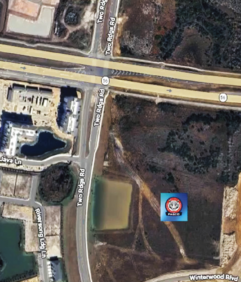
The potential site of the new brewery is inside the Two Rivers community, specifically in the Two Rivers West section (see map).
According to conceptual plans (see rendering above), the brewery would be located roughly a quarter of a mile behind a proposed Publix on S.R. 56, and just off the roundabout that leads residents to an upcoming resort-style private club known as “The Landing.”
But, the brewery itself might only be part of the story. The concept appears within a planned village-style retail district called Hawthorn Village (labeled “SITE” on the map), which is being developed by Two Rivers developer the Eisenhower Property Group.
Leasing materials from Colliers describe the village center as a 42,000-square-foot hub for specialty restaurants and boutique retail.
At the heart of the project would be an outdoor event lawn designed to host community gatherings, holiday celebrations and al fresco dining. The hypothetical brewery concept even suggests it could share space with a coffee shop and restaurant on the same property, creating more of a social hub than just another place to grab a pint.
In many ways, that’s the bigger story.
Village-style centers like this are becoming a defining feature of many modern master-planned communities. Instead of long commercial strips, these smaller walkable hubs are designed to bring neighbors together for food, entertainment, and local events.
Two Rivers itself is being planned with 13 distinct villages and a long list of lifestyle amenities, including the aforementioned The Landing private social club, a Pasco K-8 school, the Peak Surf Park, a proposed golf course on the Hillsborough side of Two Rivers, plus miles of scenic nature trails, kids’ play areas and resort-style pools.
If Hawthorn Village does eventually land a brewery, it would certainly be a welcome addition for many residents.
But, more important is that it signals the continued evolution of our area — from a quiet suburban crossroads into a place building its own identity, gathering spaces and community traditions. While many long-time local residents aren’t happy about this transformation, it is happening.
And, if that new identity happens to include a few good local beers along the way, many neighbors probably won’t complain.
(Above, l.-r.) Gen. Tom Landwermeyer & Cpls. Eddie Ward and Roberto Cruz-Arocho.
Even though their homes are being built in San Antonio (near St. Leo University), the Neighborhood News was proud to again be on hand for the introduction ceremony for the next two recipients of mortgage-free homes provided by Homes For Our Troops (HFOT) — retired Army Cpls. Eddie Ward and Roberto Cruz-Arocho, both of whom were seriously combat-wounded (Ward in Afghanistan and Cruz-Arocho in Iraq).
Cpl. Ward and his father Elijah Petty. (seated)
On hand for HFOT — a top-rated military nonprofit organization that has provided more than 420 of these specially-adapted homes for U.S. military vets injured since 9/11 — was the organization’s president & CEO, retired Army Brigadier General Tom Landwermeyer, who again reiterated that HFOT receives no government funding and that nearly 90 cents of every dollar raised by the nonprofit directly benefits the wounded veterans.
The custom-designed homes — which will each include as many as 40 special adaptations for these two wounded vets — are being built by Elizabeth Evans Custom Homes, which previously also provided two HFOT homes in Wesley Chapel.
Cpl. Ward and Cpl. Cruz-Arocho both expressed their appreciation for HFOT and for the 100 or so local people in attendance. For more info about HFOT, visit HFOTUSA.org. — GN
Elizabeth Evans (holding dog) of Elizabeth Evans Custom Homes. (l.-r.) Cpl. Cruz-Arocho & his daughters Layza & Adriana & the retired corporal’s mom.
If You Want To Know What All Those Roadside Cameras & More Are & What They Actually Do & Don’t Do, Read On!
If you drive around Wesley Chapel and New Tampa long enough, you’ll notice all kinds of devices mounted on poles, arms and cabinets along our roadways.
We’re sure you’ve seen those cameras, sensors, flashing signs, small towers — and may have been wondering what they all actually do.
Before I began writing for this publication, I spent 22 years in civil and transportation engineering and planning, including 19 years specializing in traffic operations engineering, including for the Florida Dept. of Transportation (FDOT).
I’ve worked on everything from single-family homes and bridges to diverging diamond interchanges and large-scale community developments. Most importantly, I designed and implemented Intelligent Transportation Systems (ITS) throughout the Tampa Bay area.
In that time, I’ve heard nearly every guess imaginable about what tall of these roadside devices are capable of. Let’s clear up some of the most common misconceptions and explain what you’re actually seeing out there — and whether actual speed cameras may be on the horizon.
5G Small Cell Towers
These are probably the most misidentified roadside devices — and they have nothing to do with traffic control.
Because they’re allowed in the public right-of-ways, many people assume they’re traffic-related. In reality, these short roadside poles (above) are 5G “small cells” or microcells. They’re compact antennas, usually 10–30 feet tall, mounted on utility poles, streetlights, or even traffic signal structures.
They provide high-speed cellular and internet service in a limited radius. Since 5G signals have shorter range and are easily blocked by buildings and trees, these units must be installed more densely in urban and suburban areas like ours. Bottom line: They’re for your phone — not for monitoring your driving.
When people see cameras at intersections, many immediately assume they’re red light cameras. Most of the time, they are not. PTZ CCTV cameras (both photos, left & right) are commonly used for roadway monitoring. You’ll see them mounted on poles, on mast arms near signal heads, or on tall “high mast” structures.
They allow city, county, and state staff inside traffic management centers to actively monitor traffic conditions — crashes, congestion, disabled vehicles, or signal timing issues.
Here’s the key point: These cameras typically do not record. They are live-view tools. You can identify them by the large rotating base that allows 360-degree movement and zoom capability.
Important: These cameras do not record video. They function strictly as detection devices.
If you see a camera at a signal without that large rotating base, it’s likely not for surveillance — it’s probably a traffic detection camera (see below).
360º Traffic Detection Cameras
These cameras (right) are becoming increasingly common as older loop systems (below) are phased out. Unlike older directional cameras, these units look down over an entire intersection with a wide field of view.
Typically, two are installed at opposite corners, mounted high for maximum accuracy.
They create “virtual detection zones.” When your vehicle enters one of those zones, it tells the traffic control device that a car is waiting and may trigger a signal change.
Traffic Signal Loops
What about those rectangular or oval cuts (left) in the pavement near stop bars? Those are “inductive loops” — the oldest and still very reliable method of detecting vehicles at signals.
They are not weight sensors. They function like large metal detectors. A coiled wire embedded in the pavement creates an electromagnetic field. When a vehicle moves over the loops, it disrupts the field, signaling the control device that a vehicle is present.
Note-If loops are present, your vehicle MUST be positioned over them to receive a green light.
Dilemma Zone Loops
If you see similar small loops as those above further back from a high-speed intersection, those may be dilemma zone detectors. These detect vehicles approaching during the critical moment when the light is about to change from green to yellow.
If a vehicle is detected in that “decision zone,” the system may extend the green phase to prevent abrupt braking or red-light violations.
Count Station Loops
If loops are located away from signals or just downstream of an intersection, they are likely permanent traffic count stations (photo right). These record vehicle totals to help engineers determine roadway usage and future expansion needs.
Microwave Vehicle Detection Systems (MVDS, aka Side-Fire Radar)
These pole-mounted MVDS radar units (left) are part of modern Intelligent Transportation System (ITS) deployments. Often called “side-fire radar,” they use low-power microwave signals to measure vehicle speed, lane presence, volume and even detect backups.
MVDS are non-invasive — meaning no pavement cuts are required — and provide valuable real-time data to improve operations and detect incidents.
Opticom Emergency Vehicle Detectors
These small black vertical devices mounted near signal heads (right) are extremely important. Opticom systems allow emergency vehicles — fire trucks, ambulances, and law enforcement — to request a green light as they approach an intersection.
Using infrared, radio, or GPS-based communication, they signal the traffic control device to provide priority. This reduces response times and improves safety for both emergency responders and the public.
Video Traffic Count Stations
You may have seen poles with large solar panels near their bases (left) set up along busy roads. These are video traffic counters used for planning studies and monitoring.
They use high-mounted, low-resolution cameras and AI software to count vehicles, classify them (cars, trucks, bikes, pedestrians), and track turning movements.
Note-These traffic counters do not read license plates, nor do they record faces.
Their sole purpose is for traffic analysis — often in preparation for development reviews or roadway improvements. If you see a unit with a much smaller solar panel mounted directly on top of a camera, that’s likely something different.
License Plate Readers (Flock Cameras)
Those black cameras (right), with smaller top-mounted solar panels, are typically Flock Safety License Plate Readers, used by law enforcement agencies such as the Pasco County and Hillsborough County Sheriff’s Offices, as well as some HOAs and CDDs.
These systems scan license plates and vehicle characteristics in real time and compare them to databases for stolen vehicles, wanted suspects, or AMBER alerts.
They are not used for traffic signal timing or speed enforcement. Their primary role is crime prevention and investigation.
Red Light Cameras
Despite popular belief, not every camera near an intersection is a red light camera.
In Florida, red light cameras (left photo) must be clearly identified by a roadside sign stating “Photo Enforced” (right photo below) in advance of the intersection.
Only a limited number of intersections in our area have them, including locations like Bruce B. Downs Blvd. at E. Fletcher Ave.
It’s also important to understand that traffic signals include what engineers call “All- Red Time” — a brief interval, typically 1 to 6 seconds, where all approaches display red after the yellow phase. This provides time for vehicles to clear the intersection before opposing traffic receives a green.
Unfortunately, I’ve seen drivers slam on their brakes at yellow lights out of fear of these red light cameras, which can create rear-end crash risks. The safest action is always controlled, predictable driving.
Traffic Cabinets
Those large stainless-steel boxes near intersections (left) house the brains of the traffic control system. They are typically bare, but might be painted or wrapped. Inside are controllers, power supplies, communications equipment and detection processors. The signal controller manages everything — signal heads, pedestrian indications, detection inputs, and coordination with adjacent intersections.
You’ll often see a power meter beside the cabinet, just like on a home. Smaller attached (or standalone) cabinets typically house battery backup systems (UPS units), which can place signals into flash mode during power outages.
After major storms or hurricanes, you may also see generators plugged in to keep intersections operational during extended outages.
Wrong Way Detection Systems
Wrong-way driving prevention used to rely solely on static “Wrong Way” and “Do Not Enter” signs. Today, it’s some of the most advanced roadway technology in use. Modern systems use radar, video, or both (photo right) to detect vehicles entering exit ramps in the wrong direction. When activated, the sign perimeter flashes red lights, and alerts are automatically sent to law enforcement — including the Florida Highway Patrol.
In many cases, nearby CCTV cameras automatically turn toward the ramp so traffic operators can monitor the wrong-way vehicle’s movement.
These systems can record short video clips upon activation — one of the only permanent roadside technologies that does record, but only when triggered by a wrong-way event.
These clips are sent to the control centers (along with an automated alert) to see if the vehicle turned around on the ramp to go back in the correct direction.
Active Speed Signs/Cameras
These radar-based warning signs detect the speed of approaching vehicles and display it back to the driver. If you exceed the desired speed, the sign may flash your speed. At higher thresholds, it may flash “Slow Down” more aggressively (left).
These devices can record speed data — but not video — to help engineers evaluate driver behavior and determine whether the sign is improving safety.
They are commonly used on curves, in school zones, and on corridors where speed-related issues are a concern.
As of this writing, there are no traditional roadside speed enforcement cameras operating in Wesley Chapel or New Tampa. However, school zone speed enforcement is a developing topic. Under Florida House Bill 657, municipalities and counties are now authorized to implement school zone speed detection systems.
The Tampa City Council voted 6-1 on Feb. 19 to partner with the same vendor used by the Hillsborough Sheriff’s Office for a school zone speed camera program. If approved, Tampa could begin installing and using cameras that issue citations for speeding in school zones.
The City of New Port Richey is the only Pasco municipality using school speed zone cameras.
The Pasco County Libraries’ newest addition — the Wesley Chapel (WC) Library at Seven Oaks — is finally open (after nearly two full years of construction) and pretty much everyone we spoke with since the library opened on Feb. 23 has been thrilled with the cozy new 14,000-sq.-ft. (with a 13,000-sq.-ft. interior; the other 1,000 sq. ft. is a covered outdoor “reading porch”), $11-million library.
“It’s a little smaller than I expected,” said one young mom, “but this children’s reading area (photo, above and below left picture) is amazing!”
Although branch manager Julie Shepherd (at right in right photo) couldn’t tell me on opening day exactly how large that children’s area is, but, by my estimate, it is somewhere in the neighborhood of 5,000-sq.- ft. If accurate, that would mean it takes up more than a third of the library’s inside space, with shelves full of cool kids books and interesting spaces for parents to read to their kids.
But, the library’s overall size is a little small, especially when compared with the Land O’Lakes Library (18,000+ sq. ft.) or the New Tampa Regional Library (25,000-sq. ft.).
“But, I think it’s a wonderful space,” said Roz Fenton (below right photo), the president of the countywide Friends of the Library, who was on hand for the opening. “Did you see the art on the entrance walls? That was all done by Pasco County Library staff members. Fabulous, right?”
In addition to books, magazines and the “Library of Things” — a collection of non-traditional, check-outable items, including adaptive toys, Wi-Fi hotspots, ukuleles, bird-watching kits and board games designed for enrichment and exploration — the library also features public computers, printers, collaborative spaces, a gallery wall in the lobby, an outdoor event lawn and a multi-purpose room for makerspace and other activities.
Pasco Library Friends president Roz Fenton
There’s also a sizable meeting room, and a number of study rooms, including a specially-designed teen study room. Drive-up services also are available at this location, which has its entrance on Mystic Oak Blvd., next to Seven Oaks Elementary.
There’s no doubt that the opening day was a soft opening, attended by only a few dozen people — many of whom (including Jannah and yours truly) were signing up for library cards — and that all of the new library’s programming wasn’t yet in place.
Here are the activities scheduled for the rest of March & April at the WC Library:
Thursday, March 19, 4 p.m. — Wesley Chapel Book Club: The Anthropocene Reviewed by John Green
Every Tuesday, 10:30 a.m. — Preschool Story Time
Every Friday, 10:30 a.m. — Toddler Story Time
Monday, March 23, 4 p.m. — Teen Advisory Board & Volunteer Info Session
Wednesday, March 25, 6 p.m. — Adult Volunteer Info Session
Wednesday, April 15, 4:30 p.m. — Adult Literacy New Tutor Training
Thursday, April 16, 4 p.m. — Wesley Chapel Book Club: The Ministry of Time by Kaliane Bradley
Wednesdays, April 22 & 29, 6 p.m. — English Conversation Corner
Wednesday, April 29, 5 p.m. — Adult Volunteer Orientation
What About Those ‘Makerspaces?’
“We’re going to be hosting our ‘Mobile Makerspace’ at the Wesley Chapel branch,” Shepherd told me the day the WC Library opened. “The idea is to bring the best of all of our other makerspaces to Wesley Chapel and offer a variety of different services.”
Among those makerspaces, each of which will be making appearances at the WC Library in the future, are the following:
• “The Loft” studio arts, painting, photo digitalization and arts & crafts, from the Centennial Park Library
• “The Ingenuity Lab” STEAM area, with KEVA planks & LEGO® bricks, from the Hugh Embry Library
• “Studio H” multimedia studio for record demos & podcasts and to practice instruments, from the Hudson Library
Part of the Pasco Library staff Art Show
• “The Foundry” complete wood shop, plus fabric arts & crafts center, from the Land O’Lakes Library
• “Discovery Gardens” community garden, butterfly garden & gardening demonstrations, from the New River Library
• “Regency Fresh” full test kitchen with cooking demonstrations and the chance to try new recipes, from the Regency Park Library
• “Clayworks” ceramics studio, from the Starkey Ranch Theatre Library Cultural Center
Shepherd also said that the large lawn outside of the library will be able to host a variety of cultural events, including concerts, movie nights and more. “And, we definitely will have a great relationship with the [Seven Oaks] elementary school next door,” Shepherd said. “The children’s reading area will be open anytime the library is and we will be able to host story times and even kids’ performances in that room.”
The Wesley Chapel Library at Seven Oaks is located at 27531 Mystic Oak Blvd. It is open Mon. & Wed. 10 a.m.-8 p.m., 10 a.m.- 6 p.m. on Tues. & Thur. & 10 a.m.-5 p.m. on Fri. & Sat. It is closed on Sun. For more info, visit PascoLibraries.org.
Yard House Unconfirmed But Now Rumored To Be The Front Runner To Replace Bahama Breeze On S.R. 56
Above is an absolutely not-to-scale NN composite map showing the existing businesses on the south side of Wesley Chapel (WC) Blvd. between Old Pasco Rd. & Gateway Blvd., with the site plan for the now-under-construction Gateway Plaza Retail Center superimposed to show the approximate location of Olive Garden (believed to be “Restaurant #1” on map) and Seasons 52 (believed to be “Restaurant #2”). The project also will include a dental office that will have its entrance off Gateway Blvd. The map shows Centerline Dr., which starts behind Slim Chickens, intersecting with the new plaza, but does not properly show where WC Blvd. & Gateway Blvd. connect to it. (NN-created map sources: Google Maps & Pasco County)
The restaurant rumor mill in the Wesley Chapel area has been swirling even more recently, with the previously announced planned closure and rebranding of the Bahama Breeze Island Grill on the north side of S.R. 56.
At almost the same time, the previously announced Olive Garden restaurant, located at the intersection of Wesley Chapel Blvd. (aka S.R. 54), Gateway Blvd. and Centerline Dr. (see map), began clearing the land for the Gateway Plaza Retail Center with Olive Garden, a dental office and a second previously unnamed restaurant.
After reading on one of the local Facebook groups that the second restaurant was going to be Seasons 52, I then had my research guy and correspondent Joel Provenzano look into the development plan and Joel did find that Seasons 52 is indeed the second restaurant coming to that site — even though Seasons 52 also was announced as one of the Darden Restaurant brands that could replace Bahama Breeze on S.R. 56.
We will keep you posted on the progress of Olive Garden and Seasons 52, but having those two Darden Brands now coming to Wesley Chapel Blvd. less than 5 miles from Bahama Breeze, seems to have narrowed even further the possible options to replace the island-themed eatery across from the Tampa Premium Outlets.
The Wesley Chapel area’s existing Darden Brands already include Longhorn Steakhouse, Chuy’s, Cheddars Scratch Kitchen and now Olive Garden and Seasons 52.
That leaves only Darden’s most upscale restaurants — Eddie V’s Prime Seafood, Ruth’s Chris Steak House and The Capital Grille, plus Yard House sports pub, with Yard House rumored (also in online chat we’ve seen) to be the front runner. But, with Bahama Breeze still 12-18 months from being repurposed and no official announcement yet forthcoming from Darden, all we can say is we’ll keep you posted.