
New Signage Posted At The Entrance To Chapel Crossings Community Off S.R. 54 Likely To Change
So, as I was driving eastbound along S.R. 54 (heading towards Zephyrhills), I noticed something that struck me as strange, for two reasons:
1) There were signs that said “Curley Rd.” in two different locations on 54 and
2) It was the first time that I had noticed this phenomenon.
Now, it may not seem like that big a deal to you, but it was to me. Why?
As our editorial researcher Joel Provenzano — who until very recently worked for the Florida Department of Transportation (aka “FDOT”) and in conjunction with the transportation planners for Pasco County — pointed out, although the left turn at the original Curley Rd. sign was often a dangerous one, the plan was for Curley Rd. to be realigned to the east and come south to meet up with Meadow Pointe Blvd., leaving the existing Curley Rd. to basically cul-de-sac at the entrance to the Chapel Pines subdivision, less than a mile north of Curley’s intersection with S.R. 54.
But, when the recession hit our area hard in 2008-09, Pasco County didn’t have the funds to realign Curley and it wasn’t until several years later that the existing intersection was even widened.
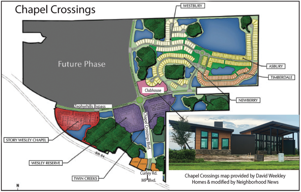
Fast forward about another decade, when Crown Community Development, which also developed Seven Oaks, begins developing the new Chapel Crossings community (see map), a pretty subdivision of about 1,100 total single- and multi-family residential units, the westernmost portion of which is the now-under-construction Story Wesley Chapel rental apartments. The only entrance to Chapel Crossings currently is on S.R. 54, at the traffic signal for Meadow Pointe Blvd.

But somehow, if you turn into that well-landscaped entrance to Chapel Crossings, the sign says that you are turning onto Curley Rd. Then, once you get into the community, the name of that same street is Chapel Crossings Blvd. What the heck?
I stopped in on at least two of the new home builders in Chapel Crossings — David Weekley Homes and Centex Homes — both of which have nice maps on their walls, showing not only their respective sections of the community, but all of Chapel Crossings. Those maps only show that main north-south thoroughfare as Chapel Crossings Blvd.
Before I continue, let me just say that I really like Chapel Crossings. It has a super-modern-looking clubhouse (photo above) that is under construction, and it will have not only a resort-style pool, fitness center and dog park, but also a lazy river. Can you say “Sold!?!”
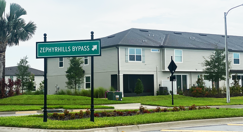
Another interesting factoid is that, when the Story apartments are completed sometime later this summer, the long-awaited Zephyhrills Bypass (photo right) also will open — or, at least, the first leg of it — which means that Chapel Crossings could have had north-south and east-west thoroughfares providing connectivity for the rest of Wesley Chapel.
The operative words, however, are “could have had.”
Joel told me that although Curley is no longer planned to be realigned through Chapel Crossings, when he left his job at FDOT, the signs at the Chapel Crossings/Curley Rd. intersection on S.R. 54 across from Meadow Pointe (MP) Blvd. had already been ordered because the county’s GIS map already had shown the southern terminus of Chapel Crossings Blvd. to be Curley Rd.
He adds, however, that Pasco also will likely still require developers to extend Chapel Crossings Blvd. further north to meet Curley Rd. at some point in the future, which would then provide that north-south connectivity mentioned earlier, just as the extension eastward of the Zephyrhills Bypass beyond Chapel Crossings will provide the east-west connectivity for Wesley Chapel.
Confused? Yes, me too. But, Joel says that, at some point, he expects Crown will request to the county to change the name of the entire length of the existing road to Chapel Crossings Blvd., which also would add some clarity and consistency with Pasco’s Vision Road plan, and so that entire roadway would have the correct same name.
In the meantime, even a Google search of Chapel Crossings shows just the end of Chapel Crossings Blvd. as Curley Rd.

