Editor’s note — The motivation for writing this story came from a post by Kelly Gilroy on her outstanding Pasco County Development & Growth Updates Facebook page. Former Florida Department of Transportation engineer — and, of course, Neighborhood News correspondent Joel Provenzano agreed that it was worth a deeper dive into what Kelly so perfectly presented. — GN
If you’ve driven around Wesley Chapel lately, you don’t need a traffic study to know one thing: Pasco County is growing fast. New neighborhoods, shopping centers, hospitals and medical offices and industrial parks seem to pop up overnight. With all of that growth comes an obvious question:
Who actually pays for the roads, sidewalks, and transportation infrastructure we all use?
The simple answer, of course, is “all of us,” but one of the biggest pieces of that answer is something called “mobility” (aka “impact”) fees.
What Are Mobility Fees, Anyway?
Mobility fees are one-time charges paid by developers each time a new building permit is issued. These fees help pay for the transportation improvements needed to support new growth, such as:
• New or widened roads
• Turn lanes and intersections
• Sidewalks and bike paths
• Other transportation facilities tied to development
In simple terms: new development helps pay for the new infrastructure it requires — and Pasco County has some of the highest impact fees of any county in Florida.
These fees don’t replace gas taxes or sales taxes, but they work alongside them to fund transportation
It’s also important to note that mobility fees are just one type of impact fee charged on new development in Pasco County. New construction is also subject to school impact fees, which help fund new schools and classroom capacity. And, park impact fees are used for land acquisition and creating new recreational facilities.
Together, transportation, school and park impact fees make up the bulk of the one-time charges paid when new homes and commercial projects are built. When combined, Pasco County’s total impact fee burden is often cited as among the highest in the region, reflecting both its rapid growth and the scale of infrastructure needed to support that growth
Why Are Mobility Fees Going Up?
Construction costs have skyrocketed in recent years. Roadway materials, labor and engineering costs have all increased — often sharply. Because of this, mobility fees have to be periodically updated to reflect the real cost of building roads today, instead of the costs from ten years ago.
Pasco County is allowed to update its mobility fee schedule every four years, and those updates are reviewed and recommended by the county’s Planning Commission, which looks at growth projections, construction costs and long-term transportation needs.
According to the county, Pasco is projected to add approximately 330,000 new residents over the next 20 to 25 years, requiring roughly 950 new lane miles of roads. Even with existing revenue sources, projected funding falls short of the need —which is why mobility fees matter.
How Much $ Are We Talking About?
Here’s a concrete example that helps put things in perspective:
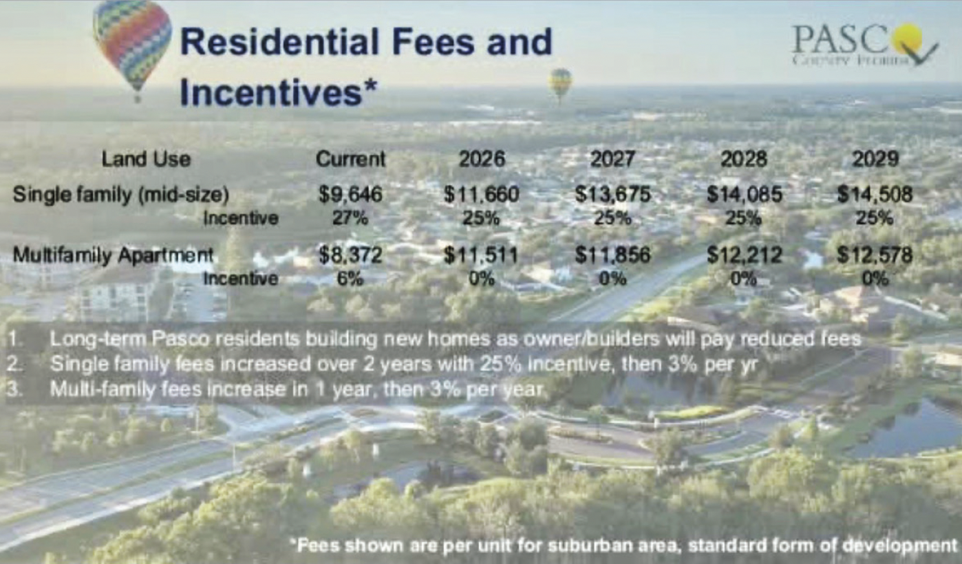
• A single-family home built in Pasco in 2026 will carry a one-time mobility fee of $11,660 that is paid by the builder.
• That money goes into county coffers for roads, sidewalks and transportation facilities.
The fee is paid once — not annually, and not by the homeowner directly at tax time. A common question is whether mobility and other impact fees on new homes are ultimately passed along to homebuyers. While opinions vary, there is little evidence this is happening in today’s market.
In many cases, new-construction homes in Pasco are priced equal to — or even less than —c comparable resale homes, which carry no such fees. Builders are also routinely offering substantial incentives, including covering large portions of closing costs and providing builder-financed mortgages with rates currently as low as 3.99% for 30 years.
Based on current pricing trends and transaction data, impact fees do not appear to be quietly “added back” elsewhere in the deal. As a result, despite these one-time development fees, new construction remains one of the most competitive and accessible options for buyers today.
Why Some Businesses Pay Nothing
This is where things get nuanced — and are often misunderstood by homeowners.
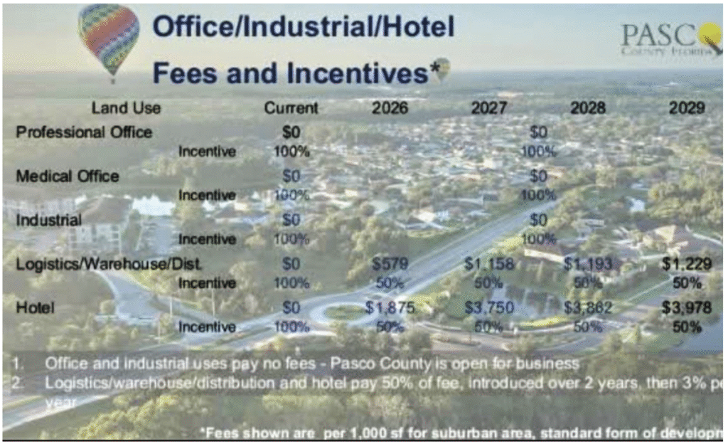
Pasco County doesn’t charge the same mobility fees to every type of development. Instead, it offers incentives to encourage certain kinds of businesses that bring higher-paying jobs and long-term economic growth, including medical & professional offices, industrial, logistics, warehouses, distribution centers and hotels
These uses currently receive a 100% incentive, meaning they pay $0 in mobility fees.
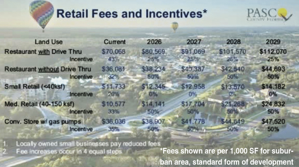
On the other hand, a fast-food restaurant with a drive-through might be charged a mobility fee of around $80,569, because it receives only a 25% incentive.
Why the difference? County officials have been clear about their goal: “Pasco is open for business,” especially for industries that diversify the tax base and bring higher-wage jobs to the county.
Who Covers The Rest Of The Cost?
This is where something called Tax Increment Financing (TIF) comes in.
TIF is often mentioned alongside mobility fees, but they work very differently:
• Mobility fees are one-time payments made upfront by developers.
• TIF uses future property tax growth to fund infrastructure over time.
Pasco County, “locks in” property tax values at a base year (2012 for unincorporated Pasco). As development happens and property values rise, the increase in tax revenue — the “increment” — is set aside.
About 33% of that increment is dedicated specifically to transportation improvements.
Those TIF funds are then used to “buy down” mobility fees for targeted developments like offices, industrial sites and hotels. In other words, the county — and its taxpayers — still funds the roads, but with future tax growth instead of charging those businesses up front for them.
Other Ways Infrastructure Is Built
Mobility fees aren’t the only way roads and infrastructure come online:
• Developers often build roads, turn lanes and/or sidewalks themselves as part of their residential or commercial projects and dedicate them to the county.
• If those improvements benefit more than just the residents of those developments, the developers can apply for mobility fee credits.
• Some communities (including many in Wesley Chapel) are built with Community Development Districts (CDDs) — quasi-governmental entities that maintain roads, sidewalks and landscaping within the developments themselves, rather than the county taking on that responsibility long-term.
This approach shifts some maintenance costs away from the county and onto the developments that directly benefit from them.
Why This Should Matter To You!
At the end of the day, mobility fees are about matching new growth with new infrastructure — and making sure existing residents aren’t left paying the full bill for new development.
Mobility fees are imperfect, complex and often controversial. But without them, Pasco County would face even larger funding gaps, even slower road improvements and even more pressure on general taxes.
As Pasco continues to grow, understanding how these fees work can help you better engage in conversations about development, transportation and the future of our community.
The growth is coming, no matter what. The real question is how we plan and pay for it.
And, most people sitting in traffic every day in Wesley Chapel believe that they are the ones paying for it — and that whatever money is coming in isn’t either not enough or not being spent fast enough to keep up — and no, they’re not wrong.
Will The ‘Rural’ Road’s Flooding Following Hurricane Milton & Clear Need For Widening Ever Be Addressed?
This is Morris Bridge Rd. looking south from the entrance to Cory Lake Isles on a usual weekday morning. For those who live along this formerly rural roadway, the daily commute to Tampa can be an absolute nightmare. So, what, if anything, is being done about it? (Photo by Joel Provenzano)
What are some of the things New Tampa and Wesley Chapel have in common?
In addition to car washes, nail salons and self-storage facilities, both rely heavily on two “major” north-south roadways — the eight- (in New Tampa) or six-lane (in Wesley Chapel) Bruce B. Downs (BBD) Blvd. and the mostly two-lane Morris Bridge (MB) Rd — as important daily travel routes.
Due to the explosive growth in both K-Bar Ranch/Easton Park in New Tampa and, especially, in the plethora of new developments in and near Wesley Chapel, dependence upon MB Rd. has continued to grow year after year.
However, traveling on the winding, two-lane MB Rd. from the Fletcher Ave. exit off I-75 in Hillsborough up into Pasco County can be a white-knuckle experience for any motorist, bicyclist or pedestrian — and for more than just one reason.
Development has caused this formerly rural roadway to be plagued by flooding (resulting in closures), as well as by heavy traffic, safety concerns, poor road conditions and some other silly stuff that commuters in both New Tampa and Wesley Chapel have to deal with every day.
With three mattresses tied to a roof, even a single Nissan Altima going 25 mph at rush hour can create havoc on MB Rd., generating a quarter-mile-long backup of angry drivers, all inching over the centerline to see if they can pass. Yes, we observed this while standing outside our vehicle and taking photos from the entrance to Cory Lake Isles!
We reached out to both Hillsborough County and City of Tampa governmental officials to find out their thoughts, and if there are any “real” projects actually moving forward to improve MB Rd. We provided them with a list of questions that did generate some responses.
We specifically asked if there were any planned capacity or safety improvement projects in the works, especially any widening plans to handle future volumes, or how the county (since MB Rd. is a county road that serves both city and county residents, as does BBD) plans to handle those traffic volumes that are expected to significantly increase over next few years, due to development on the north end — primarily the continuing expansion of K-Bar Ranch and the massive Two Rivers development, which is really just getting started building near MB Rd. both north and south of the Hillsborough-Pasco county line.
In short, much-needed flooding countermeasures have been installed (following the multi-week shutdown of MB Rd. north of Cross Creek [CC] Blvd. following Hurricane Milton last October) and both a safety project and resurfacing project are coming, but any real vehicle capacity/ modernization projects are still up in the air. District 7 Tampa City Council member Luis Viera, in his final term in his seat, at least has an idea about how to address the everyday traffic on MB Rd.
Councilman Viera’s Perspective
Although MB Rd. is entirely a county roadway, roughly 1/3 of the people living along the roadway live within Tampa’s city limits, with all of those residents (at least until the Hillsborough portion of Two Rivers begins building) living in the city-based New Tampa developments of Cory Lake Isles, Easton Park and K-Bar Ranch.
As such, we were grateful to interview Viera to get his opinion about some of the county’s responses, and what he’d like to see done as a proven champion of innovative intergovernmental (meaning city and county) collaboration.
He specifically notes that there’s a, “Need to modernize Morris Bridge. The City has to work with the county on long- term solutions,” indicating that county officials can’t, and shouldn’t have to, try to fix MB Rd. all by themselves.
Viera believes that one of the biggest issues in the past (in regards to capacity improvements) has been the obvious environmental concerns, since MB Rd. winds past thousands of acres of multiple county parks (Flatwoods, Morris Bridge Park, etc.). He explains that, “We need to be respectful of the environment, but the environmental issues have been the biggest roadblock (to improving MB Rd.).”
Viera clearly believes that NOW is the time for a change. “You know what?,” he says. “Next week [the week of March 24, or after we went to press with this issue], I’m going to make a motion to City Council,” in regards to creating a shared vision for MB Rd. by having the city reach out to the county.
Since the road actually winds through two counties, Viera says he also plans to reach out to District 2 Pasco County Commissioner Seth Weightman (who represents the portion of Wesley Chapel directly to the west and north of the county line at MB Rd.) to also try to get Pasco’s buy-in and help with that shared vision.
Since several places of worship, and multiple new businesses and communities are quickly popping up along the route, he feels the “rural nature” of the road isn’t keeping up with the times or its now more modern suburban context.
A Little History
While the original Morris “Bridge” is long gone, a bridge that was originally located just north of the Pasco County line (near where an underwhelming box culvert now sits), MB Rd. still exists as an “old” rural road abutted by suburban communities.
How old? Apparently, more than 100 years old! In fact, MB Rd. may be one of the oldest surviving (and continually used) county arterial roads in Tampa, coming from a time when maps of the county and state were more likely to show railroads than roads, because that was the primary form of transportation for those traveling long distances.
Without these primitive roads being shown on maps, their existence, location, and purpose had to be shared by word of mouth and/or in newspaper articles, especially for newer routes. What was written over a hundred years ago about Morris Bridge as a fledgling route was absolutely fascinating.
In its June 1, 1923, edition, The Dade City Banner (photo, left) had the following article:
GOOD ROUTE OPEN TO TAMPA
BY WAY OF MORRIS BRIDGE
“The recent heavy rains having made the route [where S.R. 39 sits today] to Tampa by way of Crystal Springs and Plant City impassable, there has been considerable inquiry as to another route that could be used by parties who found it necessary to visit the South Florida metropolis and did not care to avail themselves of the convenient train schedules. A number of people have been making the trip lately by way of the Morris Bridge and pronounce that route not only perfectly passable but a surprisingly good one. It is about 12 miles shorter than by way of Plant City.
To follow this route one turns west at the railroad crossing at Zephyrhills, goes to Will Ryals farm, about a mile from town, from there to Jim Hills’ place. Here take a plain road running southwest and at all forks take the one running in that direction. This road is said to be graded the entire distance and, from the Morris Bridge at the county line to Harney has been clayen [sand-clay]. From Harney a brick road leads to Tampa.”
This is funny, because to this day, Morris Bridge Rd. still becomes Harney Rd. at its very southern terminus in Temple Terrace.
Flooding Concerns
Speaking of flooding and impassable roads, our field review showed where repairs had been done when the road was flooded (and closed) multiple times last year. We asked Hillsborough County staffers if these repairs were permanent fixes that will reduce flooding and road closures in the future, or just temporary fixes to repair the damage?
Todd Pratt, who is with the Hillsborough County Media Relations Department, says that, “The repairs done after Milton were permanent fixes that consisted of replacing culverts that convey water under and across Morris Bridge Rd. These culverts had collapsed/washed out during the hurricane.”
Time, and the next major rainy season, will tell if these repairs will hold, or if new ones will be needed.
Safety Improvement Project
Regarding MB Rd. safety projects, Hillsborough senior media relations strategist Chris Wilkerson says that, “Morris Bridge Road has a planned safety improvement project (see below) slated to begin later this year. The contract for the project is planned to go before the BOCC (Board of County Commissioners) in April. If approved, the project would address safety concerns on the roadway, including documented consistent high rates of speed and distracted drivers. The project is designed to address speeding and motorist lane departure crashes.”
Proposed Safety Improvements – $2.1 million:
• No Passing Zones w/Vertical Delineators
• Reflective & Profiled Lane Line Markings
• Speed Feedback Signs, Flashing Beacons for Intersection Ahead & Curve Warning & Signal Head Back Plates
• Bike Lane & Safety Enhancements at Bridge over Hillsborough River
• Bicycle Signs and Lane Markings & Wildlife Signs
Meanwhile, Viera says that, “$2.1 million is wonderful, but we need to push that envelope!,” although he says he is really happy to see that “speed feedback signs” and “no passing” enhancements, are part of the safety project, as these would address issues his constituents have discussed with him.
Prior 1% Surtax to Fund Resurfacing
The last time MB Rd. (at least north of CC Blvd.) was resurfaced was way back in 2002. The portion south of CC Blvd. is in somewhat better shape, as it was last resurfaced in 2017.
A physical review we conducted of the corridor noted aging/deteriorating pavement with potholes, multiple patches, narrow, worn or no shoulders, no sidewalks (except self-funded ones in front of a few businesses) and very narrow lane widths at a few points (mostly north of Cory Lake Isles approaching and into Pasco County).
So, is MB Rd. on the county’s list of roadways to be resurfaced? We hadn’t previously seen or heard of MB Rd. as being on any 3R (Resurfacing, Restoration, Rehabilitation) project list.
But, Pratt told us, “The Florida Legislature has identified repaving projects to be completed in Hillsborough County using a portion of the previously collected Transportation Surtax funds (see below). One of the roads to be repaved is Morris Bridge Road. The County will need to coordinate this paving to be done in conjunction with the safety improvement project.”
Confused? You may recall that back in 2018, Hillsborough County voters had passed a one-cent sales tax to fund needed transportation projects. This tax ended up being legally challenged, and was found to be unconstitutional by the Florida Supreme Court in March 2021. But, by then, the county had already collected about $589 million from local taxpayers.
After the tax was eliminated, state lawmakers went ahead and made a plan to split that collected money up between county road improvement projects, a Hillsborough tax holiday, reimbursement of the county’s legal fees, and a settlement fund that would allow Hillsborough taxpayers and residents to receive refunds (up to $100 without showing any receipts).
That plan began about a year ago, when county commissioners met to start dividing up the funds. It was decided that about $256 million would go towards road projects (including road resurfacing). At the beginning of March of this year, the first $17 million of that money started being distributed, with all of the funds expected to reach the long list of target projects by 2030.
The Florida Department of Transportation (FDOT) is slated to make sure the county completes these projects by the deadline. That overall plan will be up for approval at one of the upcoming BOCC meetings in April.
Capacity Concerns
At our press time, county officials had not yet responded to our most pressing question — How does the county plan to handle MB Rd. volumes that surely will significantly increase over next few years due to development on the north end of the road (from K-Bar Ranch, Two Rivers and other Pasco developments), and what those forecasted volumes (if they’ve been forecasted through traffic studies or other models) might be, compared with recent historic volumes (meaning, how much growth in percentage or number of vehicles is expected?).
Current state data shows an annual average daily traffic (or AADT) of 15,000 vehicles per day for MB Rd.. (Note-AADT is the total number, in both directions, of vehicular trips taken on that road each day, divided by 365 days in a year.)
Based on our preliminary calculations, it would not be unreasonable to see an increase of 20% in the traffic volumes over the next few years, given the size of the future developments that will be connected to the road.
As we had written in a previous article from April of 2024, the final phase of K-Bar Ranch in Hillsborough will add hundreds more homes, and open up ALL of K-Bar to MB Rd. via an extension of K-Bar Ranch Pkwy. to the east, past Easton Park. Once that extension has been completed, this also will subsequently open all of the Union Park and Meadow Pointe developments in Wesley Chapel to MB Rd. as well, via the planned Wyndfields Blvd. extension to the south, and the existing Meadow Pointe Blvd. extension.
The 6,000-acre Two Rivers development on the edge of Wesley Chapel and New Tampa (although it actually is located in Zephyrhills in Pasco and Thonotosassa in Hillsborough) will be adding an estimated 7,500 more residences, plus commercial developments, the Peak Surf Park and schools, with its north-south traffic to be split between U.S. Hwy. 301 and MB Rd. But, as anyone living in the area might imagine, it will still have a significant impact on MB Rd.
Bridge Scouring
The current bridge over the Hillsborough River on MB Rd. was built in 1963. Since then, its piers have experienced significant base erosion, which is referred to as “scouring,” a critical problem that can affect the bridge’s structural sturdiness if not properly addressed.
Based on a fact sheet put out in January 2025,Hillsborough plans to spend roughly $864,000 to, “install an articulating concrete block revetment system as a scour countermeasure.” Revetment is just a fancy way of saying a sloping structure that is usually made of stone or concrete, used to protect the riverbed around piers from erosion caused by river currents or other forces. Otherwise, the piers can become unstable if too much of the bed is eroded, which is why this is a critical repair.
Construction of the revetment system is expected to be completed by early 2027.
So, How Can I Get Involved?
Believe it or not, your elected officials actually want — or even, make that need — to hear your traffic and safety concerns about MB Rd.
So, how can you get involved? In addition to contacting your local county representative — District 2 Commissioner Ken Hagan — Councilman Viera wants everyone to know that he has an upcoming New Tampa Community public meeting, on Tuesday, April 15, 5:45 p.m., at the Easton Park Community Pool Clubhouse (10776 Pictorial Park Dr., Tampa).
Viera says he will be on hand at that meeting to receive input, answer questions, and talk about MB Rd., as well as about crime, education, housing, the progress on the planned park in K-Bar Ranch and pretty much anything else New Tampa or even Tampa-related.
Viera will be joined by a representative of the Tampa Police Department at that Town Hall-style event, as well as by District 6 (countywide) Hillsborough School Board member Karen Perez.
For more information about that meeting, email luis.viera@tampagov.net.
All approaches to the traffic signals on S.R. 56 and Mansfield Blvd. now have dual left turn lanes. The under-construction Orlando Health Hospital is seen here in the background.
A major traffic pattern change has just been competed at the intersection of Mansfield Blvd./Wiregrass Ranch Blvd. and S.R. 56, as there are now dual left turn lanes in all directions. This change occurred rather quickly last month and only took a few weeks to finish.
The change was a requirement of the Florida Department of Transportation (FDOT) and Pasco County permitting conditions for the new Orlando Health Hospital, being constructed at the northeast corner of the intersection. This means that the hospital paid for and completed the work in advance of its anticipated opening, which is still expected to be sometime in 2026.
The change was required to help offset and accommodate the additional traffic the hospital is expected to generate at that intersection, which was laid out in Orlando Health’s traffic study, which was submitted in advance of the project for government review. These operational and safety improvements should keep the signal working efficiently long into the future.
The S.R. 56 intersection with Mansfield/Wiregrass Ranch Blvd.
All of the signals at the intersection had always been designed to accommodate these extra left turn lanes, but they were striped out with paint until needed. The first dual left (from Mansfield Blvd. northbound onto S.R. 56 westbound) was added in 2018 when FDOT contacted Pasco to let the county know that vehicular traffic leaving the schools in the morning was causing backups on Mansfield Blvd., creating a concern — and sometimes long delays — for local residents.
Safety has always been a concern here as well, as there have been multiple serious crashes involving younger drivers making left turns in front of oncoming traffic under the previous permissive left turn signal. Now, with the dual lefts, all left turns are protected, which means left turns are only permitted with a green arrow, greatly reducing the potential for crashes.
There’s also still room to add a third through lane in both the westbound and eastbound directions on S.R. 56 in the striped-out area, when needed.
Meadow Pointe Blvd. Still A Concern
Meanwhile, safety and efficiency are still concerns with the down stream signal at Meadow Pointe Blvd. and S.R. 56.
District 2 Pasco County Commissioner Seth Weightman has said that improvements are coming to this intersection as well, an item that the Board of County Commissioners (BOC) passed in July.
Dual lefts will be added for eastbound traffic on S.R. 56 to turn north onto Meadow Pointe Blvd., which backs up badly during the afternoon rush hour, and dual lefts will be added for northbound traffic on Meadow Pointe Blvd. to turn west onto S.R. 56, which experiences bad back-ups during both the morning and evening rush hours.
New Signage Posted At The Entrance To Chapel Crossings Community Off S.R. 54 Likely To Change
So, as I was driving eastbound along S.R. 54 (heading towards Zephyrhills), I noticed something that struck me as strange, for two reasons:
1) There were signs that said “Curley Rd.” in two different locations on 54 and
2) It was the first time that I had noticed this phenomenon.
Now, it may not seem like that big a deal to you, but it was to me. Why?
As our editorial researcher Joel Provenzano — who until very recently worked for the Florida Department of Transportation (aka “FDOT”) and in conjunction with the transportation planners for Pasco County — pointed out, although the left turn at the original Curley Rd. sign was often a dangerous one, the plan was for Curley Rd. to be realigned to the east and come south to meet up with Meadow Pointe Blvd., leaving the existing Curley Rd. to basically cul-de-sac at the entrance to the Chapel Pines subdivision, less than a mile north of Curley’s intersection with S.R. 54.
But, when the recession hit our area hard in 2008-09, Pasco County didn’t have the funds to realign Curley and it wasn’t until several years later that the existing intersection was even widened.
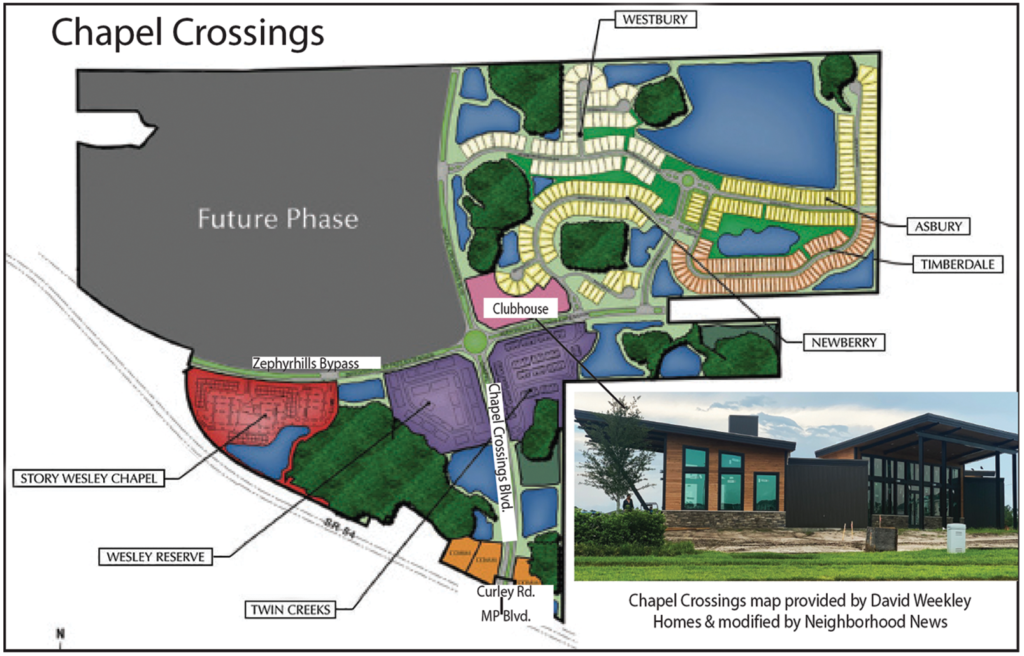
Fast forward about another decade, when Crown Community Development, which also developed Seven Oaks, begins developing the new Chapel Crossings community (see map), a pretty subdivision of about 1,100 total single- and multi-family residential units, the westernmost portion of which is the now-under-construction Story Wesley Chapel rental apartments. The only entrance to Chapel Crossings currently is on S.R. 54, at the traffic signal for Meadow Pointe Blvd.
But somehow, if you turn into that well-landscaped entrance to Chapel Crossings, the sign says that you are turning onto Curley Rd. Then, once you get into the community, the name of that same street is Chapel Crossings Blvd. What the heck?
I stopped in on at least two of the new home builders in Chapel Crossings — David Weekley Homes and Centex Homes — both of which have nice maps on their walls, showing not only their respective sections of the community, but all of Chapel Crossings. Those maps only show that main north-south thoroughfare as Chapel Crossings Blvd.
Before I continue, let me just say that I really like Chapel Crossings. It has a super-modern-looking clubhouse (photo above) that is under construction, and it will have not only a resort-style pool, fitness center and dog park, but also a lazy river. Can you say “Sold!?!”
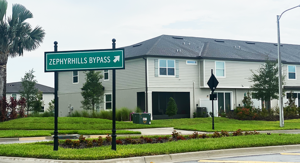
Another interesting factoid is that, when the Story apartments are completed sometime later this summer, the long-awaited Zephyhrills Bypass (photo right) also will open — or, at least, the first leg of it — which means that Chapel Crossings could have had north-south and east-west thoroughfares providing connectivity for the rest of Wesley Chapel.
The operative words, however, are “could have had.”
Joel told me that although Curley is no longer planned to be realigned through Chapel Crossings, when he left his job at FDOT, the signs at the Chapel Crossings/Curley Rd. intersection on S.R. 54 across from Meadow Pointe (MP) Blvd. had already been ordered because the county’s GIS map already had shown the southern terminus of Chapel Crossings Blvd. to be Curley Rd.
He adds, however, that Pasco also will likely still require developers to extend Chapel Crossings Blvd. further north to meet Curley Rd. at some point in the future, which would then provide that north-south connectivity mentioned earlier, just as the extension eastward of the Zephyrhills Bypass beyond Chapel Crossings will provide the east-west connectivity for Wesley Chapel.
Confused? Yes, me too. But, Joel says that, at some point, he expects Crown will request to the county to change the name of the entire length of the existing road to Chapel Crossings Blvd., which also would add some clarity and consistency with Pasco’s Vision Road plan, and so that entire roadway would have the correct same name.
In the meantime, even a Google search of Chapel Crossings shows just the end of Chapel Crossings Blvd. as Curley Rd.
With $20 million earmarked for sidewalk repairs, but $15 million of that designated for underserved neighborhoods, will the county’s recent vote impact New Tampa? (Photo: John C. Cotey)
The Hillsborough County Board of County Commissioners (BOCC) committed a large chunk of money to repaving many of its roads last year. This year, the BOCC is tackling sidewalks.
The commissioners voted 6-1 on May 4 to spend $20 million from the county’s remaining pool of America Rescue Plan Act (ARPA) funds to address dangerous sidewalks damaged over the years by tree roots, vehicles and age. District 7 Commissioner Kimberly Overman was the lone dissenter, stating a preference that the $20 million be spent on addressing the affordable housing crisis instead.
The county received $285.9 million from the federal Covid-19 relief package in 2021 and, after the sidewalk appropriations, will have about $44 million remaining.
Which sidewalks will be fixed, and whether any of those are in New Tampa, won’t be known for another month or so (90 days from the meeting), and commissioners will meet with county planners to determine the areas of need.
District 2 commissioner Ken Hagan, who represents the New Tampa area, told commissioners at the meeting that, “sidewalk repairs and road resurfacing are by far the top requests to my office.”
Damaged and uneven sidewalks are a major concern, commissioners said. Hagan shared the story of one constituent who says their children wait in the street for the school bus in the morning because the sidewalks are so bad. In other cases, children and adults biking, the elderly out for a walk and those in wheelchairs are unable to use the sidewalk for basic things like getting to school, a store or a bus stop.
Tom Fesler, the county’s chief financial administrator, told commissioners that the county has paid out $2.5 million in claims over the last 10 years related to sidewalk trip-and-falls.
“It is one of the most significant items we have as far as claims to come to the county go,” Fesler said.
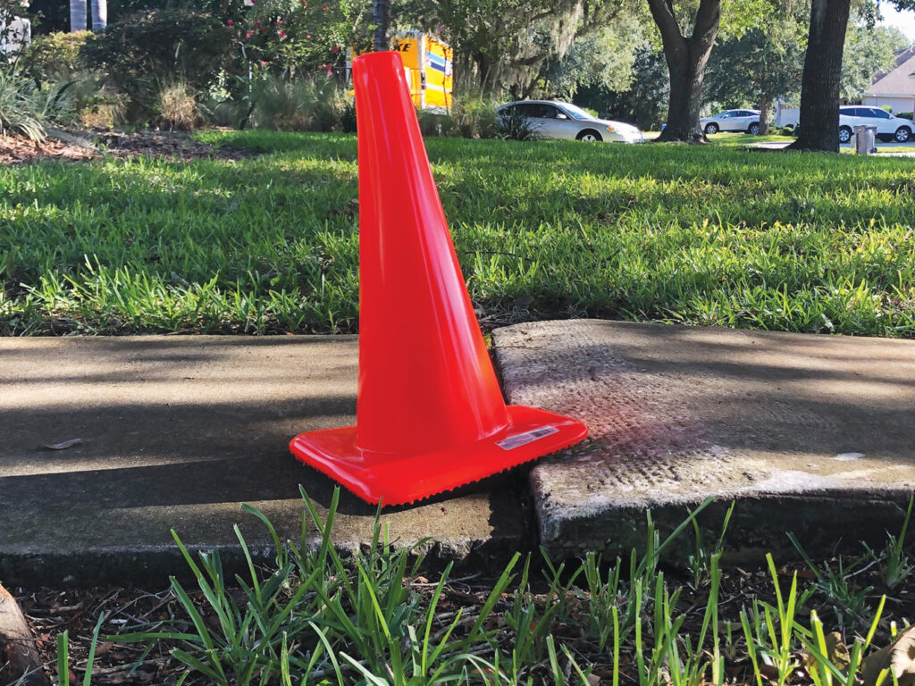
The Neighborhood News reported a story in July 2019 about the dangerous sidewalks in many of the seven neighborhoods that comprise Cross Creek. Jo-Ann Pilawski, the community association manager, said she had reported the sidewalks for years, but repairs were just added to a massive backlog. Instead, swatches of bright orange paint and dozens of orange safety cones were placed throughout the neighborhoods as warnings to pedestrians.
Three years later, the paint has faded, the cones are gone, and the uneven sidewalks remain.
Pilawski hopes the BOCC’s vote moves some of the repairs further up on the county’s to-do list.
“I keep calling,” she says.
Hagan said he has compiled a list from constituent phone calls to compare with what the county staff has come up with as to which sidewalks to address.
However, Hagan stressed that there is an 8-10 year backlog on sidewalk repairs and, at the BOCC meeting, commissioners agreed that $15 million of the $20 million voted for would be used to repair sidewalks in underserved areas.
Hillsborough County Public Works maintains more than 3,200 miles of sidewalks, with a budget of only about $550,000 a year to perform repairs. Last year, the county said it had nearly 2,500 open requests for sidewalk repairs, but the budget would only allow it to get to less than a third of those requests.
“The need is enormous,” Hagan said. “Hopefully, we are able to spread it around as much as possible and do as many sidewalks as possible.”